IMAGES TAKEN NEAR TO
Strathmartine, DUNDEE, DD3 0PQ
Introduction
This page details the photographs taken nearby to DD3 0PQ by members of the Geograph project.
The Geograph project started in 2005 with the aim of publishing, organising and preserving representative images for every square kilometre of Great Britain, Ireland and the Isle of Man.

There are currently over 7.5m images from over14,400 individuals and you can help contribute to the project by visiting https://www.geograph.org.uk
Image Map
Images are licensed for reuse under creativecommons.org/licenses/by-sa/2.0
Notes
- Clicking on the map will re-center to the selected point.
- The higher the marker number, the further away the image location is from the centre of the postcode.
Image Listing (6 Images Found)
Images are licensed for reuse under creativecommons.org/licenses/by-sa/2.0
Image
Details
Distance
1
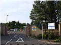
Strathmartine Hospital
Much of the southern portion of this grid box is occupied by this psychiatric, day care and rehabilitation hospital.
Image: © Val Vannet
Taken: 7 Jun 2005
0.09 miles
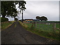
3
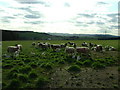
Balmydown Farm Sheep
Looking over Strathmartine Valley, Angus.
Image: © stephen samson
Taken: 15 Apr 2008
0.10 miles
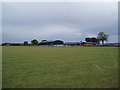
6
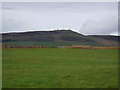
Farmland below the Sidlaws
Craigowl, the highest of the Sidlaws, dominates the landscape
Image: © Douglas Nelson
Taken: 17 Sep 2012
0.24 miles