IMAGES TAKEN NEAR TO
Blairfield Terrace, DUNDEE, DD2 5PP
Introduction
This page details the photographs taken nearby to Blairfield Terrace, DD2 5PP by members of the Geograph project.
The Geograph project started in 2005 with the aim of publishing, organising and preserving representative images for every square kilometre of Great Britain, Ireland and the Isle of Man.

There are currently over 7.5m images from over14,400 individuals and you can help contribute to the project by visiting https://www.geograph.org.uk
Image Map
Images are licensed for reuse under creativecommons.org/licenses/by-sa/2.0
Notes
- Clicking on the map will re-center to the selected point.
- The higher the marker number, the further away the image location is from the centre of the postcode.
Image Listing (10 Images Found)
Images are licensed for reuse under creativecommons.org/licenses/by-sa/2.0
Image
Details
Distance
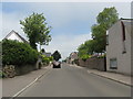
1
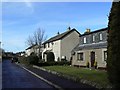
Blairfield Terrace
A residential cul-de-sac in Birkhill.
Image: © James Allan
Taken: 10 Mar 2014
0.01 miles
2
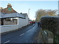
Blairfield Road
With the Birkhill Inn on the left.
Image: © James Allan
Taken: 16 Jan 2012
0.04 miles
3
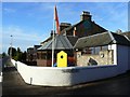
Birkhill Inn
On the corner of Blairfield Road and the A923
Image: © James Allan
Taken: 9 Nov 2009
0.04 miles

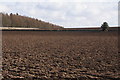
5

Birkhill main street
The A923 road to Coupar Angus from Dundee as it enters Birkhill.
Image: © James Allan
Taken: 9 Nov 2009
0.08 miles
7
Post Box Road at Birkhill in Angus
Runs off the A923.
Image: © James Denham
Taken: 4 Jun 2010
0.11 miles

9
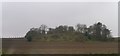
An interesting looking hill seen from the Birkie Inn
Image: © Elliott Simpson
Taken: 15 Apr 2016
0.18 miles
10
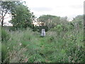
The Roundie Trig Pillar
Looking northwards to the triangulation pillar on The Roundie.
Image: © Scott Cormie
Taken: 30 Jun 2020
0.18 miles