IMAGES TAKEN NEAR TO
Lundie, DUNDEE, DD2 5NX
Introduction
This page details the photographs taken nearby to DD2 5NX by members of the Geograph project.
The Geograph project started in 2005 with the aim of publishing, organising and preserving representative images for every square kilometre of Great Britain, Ireland and the Isle of Man.

There are currently over 7.5m images from over14,400 individuals and you can help contribute to the project by visiting https://www.geograph.org.uk
Image Map
Images are licensed for reuse under creativecommons.org/licenses/by-sa/2.0
Notes
- Clicking on the map will re-center to the selected point.
- The higher the marker number, the further away the image location is from the centre of the postcode.
Image Listing (5 Images Found)
Images are licensed for reuse under creativecommons.org/licenses/by-sa/2.0
Image
Details
Distance
2
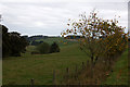
View East at Clushmill
Clushmill Burn runs through the little valley
Image: © Christopher Gillan
Taken: 20 Nov 2005
0.08 miles
3
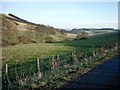
Trees along Clushmill Burn, near Lundie
Image: © Mike Pennington
Taken: 15 Oct 2013
0.10 miles
4
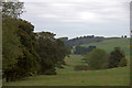
Cattle near Lundie
Cattle graze in the valley bottom, with the wooded Clushmill in the distance.
Image: © Maigheach-gheal
Taken: 10 Oct 2010
0.16 miles
5
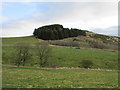
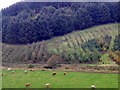
Bowhouse Hill
The tree-topped western slope of Bowhouse Hill, viewed from near Clushmill.
Image: © Scott Cormie
Taken: 1 Apr 2020
0.19 miles