IMAGES TAKEN NEAR TO
Invergowrie, DUNDEE, DD2 5LQ
Introduction
This page details the photographs taken nearby to DD2 5LQ by members of the Geograph project.
The Geograph project started in 2005 with the aim of publishing, organising and preserving representative images for every square kilometre of Great Britain, Ireland and the Isle of Man.

There are currently over 7.5m images from over14,400 individuals and you can help contribute to the project by visiting https://www.geograph.org.uk
Image Map
Images are licensed for reuse under creativecommons.org/licenses/by-sa/2.0
Notes
- Clicking on the map will re-center to the selected point.
- The higher the marker number, the further away the image location is from the centre of the postcode.
Image Listing (4 Images Found)
Images are licensed for reuse under creativecommons.org/licenses/by-sa/2.0
Image
Details
Distance
1
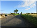
C12 (Angus) Road
The C12 road heading north towards Fowlis from the Dundee border at the Mains of Fowlis.
Image: © Scott Cormie
Taken: 26 Jul 2020
0.05 miles
2
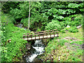
Fowlis Den
The view is taken from the minor road as it crosses Fowlis Den, drained by the Fowlis Burn
Image: © Val Vannet
Taken: 18 Jun 2005
0.07 miles
3
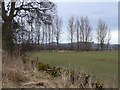
Tree-lined field
Part of Mains of Fowlis farm with Dundee in the background.
Image: © James Allan
Taken: 15 Mar 2010
0.18 miles
4
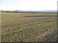
Winter cereal crop, Mains of Fowlis
Winter sown cereals and a view of Dundee.
Image: © Richard Webb
Taken: 29 Jan 2010
0.23 miles