IMAGES TAKEN NEAR TO
Longforgan, DUNDEE, DD2 5HG
Introduction
This page details the photographs taken nearby to DD2 5HG by members of the Geograph project.
The Geograph project started in 2005 with the aim of publishing, organising and preserving representative images for every square kilometre of Great Britain, Ireland and the Isle of Man.

There are currently over 7.5m images from over14,400 individuals and you can help contribute to the project by visiting https://www.geograph.org.uk
Image Map
Images are licensed for reuse under creativecommons.org/licenses/by-sa/2.0
Notes
- Clicking on the map will re-center to the selected point.
- The higher the marker number, the further away the image location is from the centre of the postcode.
Image Listing (5 Images Found)
Images are licensed for reuse under creativecommons.org/licenses/by-sa/2.0
Image
Details
Distance
2
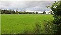
Grass and polytunnels
Farmland, Longforgan.
Image: © Richard Webb
Taken: 30 Aug 2014
0.13 miles
3
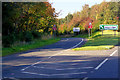
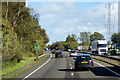
Southbound Exit from the A90 at Longforgan
Image: © David Dixon
Taken: 24 Sep 2018
0.20 miles
4
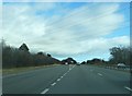
Countdown Marker, Northbound A90 near to Longforgan
Longforgan junction 100 metres ahead.
Image: © David Dixon
Taken: 19 Sep 2018
0.21 miles
5
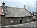
Thatched cottage
The reed beds on the Tay used to provide the thatch for cottages such as these.
Image: © Val Vannet
Taken: 18 Jun 2005
0.21 miles