IMAGES TAKEN NEAR TO
Nethergray Crescent, DUNDEE, DD2 5GN
Introduction
This page details the photographs taken nearby to Nethergray Crescent, DD2 5GN by members of the Geograph project.
The Geograph project started in 2005 with the aim of publishing, organising and preserving representative images for every square kilometre of Great Britain, Ireland and the Isle of Man.

There are currently over 7.5m images from over14,400 individuals and you can help contribute to the project by visiting https://www.geograph.org.uk
Image Map
Images are licensed for reuse under creativecommons.org/licenses/by-sa/2.0
Notes
- Clicking on the map will re-center to the selected point.
- The higher the marker number, the further away the image location is from the centre of the postcode.
Image Listing (6 Images Found)
Images are licensed for reuse under creativecommons.org/licenses/by-sa/2.0
Image
Details
Distance
1
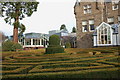
Maze in the Landmark Hotel grounds, Invergowrie
A low hedge maze in the gardens behind the former Greystane House, now incorporated into the hotel.
Image: © Jim Barton
Taken: 13 Nov 2010
0.20 miles
2
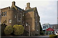
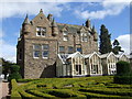
Landmark Hotel, Invergowrie
This has changed name since 2007, when it was the Swallow Hotel, as in Image The original building is Greystane House, a 19th century country house.
Image: © Jim Barton
Taken: 13 Nov 2010
0.20 miles
3
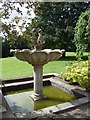
Fountain in the gardens of the former Greystane House
Now the Swallow Hotel, Invergowrie.
Image: © Stanley Howe
Taken: 1 Sep 2007
0.21 miles
4
Swallow Hotel, Invergowrie
Formerly Greystane House, featuring a low hedge maze in the gardens.
Image: © Stanley Howe
Taken: 1 Sep 2007
0.22 miles
5
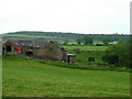
New Mill of Gray
The farm takes its name from an old mill which was located on the Lochee Burn
Image: © Val Vannet
Taken: 18 Jun 2005
0.25 miles