IMAGES TAKEN NEAR TO
Errol Road, DUNDEE, DD2 5BY
Introduction
This page details the photographs taken nearby to Errol Road, DD2 5BY by members of the Geograph project.
The Geograph project started in 2005 with the aim of publishing, organising and preserving representative images for every square kilometre of Great Britain, Ireland and the Isle of Man.

There are currently over 7.5m images from over14,400 individuals and you can help contribute to the project by visiting https://www.geograph.org.uk
Image Map
Images are licensed for reuse under creativecommons.org/licenses/by-sa/2.0
Notes
- Clicking on the map will re-center to the selected point.
- The higher the marker number, the further away the image location is from the centre of the postcode.
Image Listing (18 Images Found)
Images are licensed for reuse under creativecommons.org/licenses/by-sa/2.0
Image
Details
Distance
1
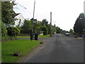
Errol Road in Invergowrie
Leaving the town en route to Errol in Perth and Kinross.
Image: © James Denham
Taken: 31 May 2010
0.02 miles
2

George V postbox on Errol Road, Invergowrie
Postbox No. DD2 142.
See Image] for context.
Image: © JThomas
Taken: 12 Jun 2021
0.04 miles
3

Houses on Errol Road, Invergowrie
Showing position of Postbox No. DD2 142.
See Image] for postbox.
Image: © JThomas
Taken: 12 Jun 2021
0.05 miles
4
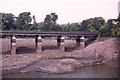
Rail bridge crossing Kingoodie quarry
The water had been pumped out of the quarry to allow an inspection of the bridge. This exercise disclosed a blacksmith's workshop to the right of this photo.
Image: © Elliott Simpson
Taken: Unknown
0.14 miles
5
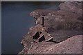
The blacksmith's workshop in the base of the quarry
Image: © Elliott Simpson
Taken: Unknown
0.16 miles
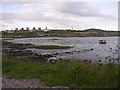
6
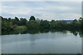
Flooded Former Quarry
Kingoodie quarry was a stone quarry on the edge of the river Tay. Information below from Canmore.org.uk
Kingoodie Quarry (NO32NW 19) was geologically and, located by the sea, physically able to supply large sandstone blocks that were especially suitable as engine foundations or for docks like London’s East and West India Docks, Dundee’s Victoria Dock and Esplanade. The quarry closed closed in 1876, to briefly re-open in 1893-1904.
Image: © David Robinson
Taken: 24 Jul 2019
0.18 miles
7
Invergowrie Bay
The view looks across Invergowrie Bay towards the west of Dundee
Image: © Val Vannet
Taken: 17 May 2005
0.18 miles
8
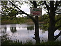
Kingoodie quarry
This former quarry is now flooded and maintained as a wildlife sanctuary
Image: © Val Vannet
Taken: 17 May 2005
0.18 miles

10
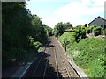
Railway towards Perth
View from the footbridge, Invergowrie Railway Station.
Image: © JThomas
Taken: 12 Jun 2021
0.21 miles