IMAGES TAKEN NEAR TO
Mylnefield Road, DUNDEE, DD2 5AT
Introduction
This page details the photographs taken nearby to Mylnefield Road, DD2 5AT by members of the Geograph project.
The Geograph project started in 2005 with the aim of publishing, organising and preserving representative images for every square kilometre of Great Britain, Ireland and the Isle of Man.

There are currently over 7.5m images from over14,400 individuals and you can help contribute to the project by visiting https://www.geograph.org.uk
Image Map
Images are licensed for reuse under creativecommons.org/licenses/by-sa/2.0
Notes
- Clicking on the map will re-center to the selected point.
- The higher the marker number, the further away the image location is from the centre of the postcode.
Image Listing (29 Images Found)
Images are licensed for reuse under creativecommons.org/licenses/by-sa/2.0
Image
Details
Distance
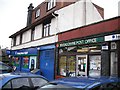
1

Invergowrie Inn
In the small town west of Dundee.
Image: © James Denham
Taken: 31 May 2010
0.05 miles
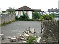
5

Broken fountain in Invergowrie Memorial Park
Image: © Nigel Thompson
Taken: 11 May 2016
0.11 miles
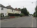
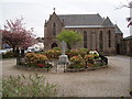
6
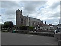
Invergowrie Parish Church
Seen from school waiting stance.
Image: © Stanley Howe
Taken: 28 Jun 2016
0.12 miles
7
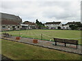
Invergowrie Bowling Club
The bowling green at Invergowrie, viewed from Errol Road.
Image: © Scott Cormie
Taken: 2 Aug 2022
0.12 miles
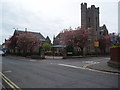
8
War Memorial and Garden of Remembrance, Invergowrie
Image: © Douglas Nelson
Taken: 5 May 2014
0.12 miles
10
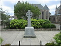
Invergowrie War Memorial
The war memorial outside Invergowrie Parish Church.
Image: © Scott Cormie
Taken: 2 Aug 2022
0.13 miles