IMAGES TAKEN NEAR TO
Buttars Street, DUNDEE, DD2 4PQ
Introduction
This page details the photographs taken nearby to Buttars Street, DD2 4PQ by members of the Geograph project.
The Geograph project started in 2005 with the aim of publishing, organising and preserving representative images for every square kilometre of Great Britain, Ireland and the Isle of Man.

There are currently over 7.5m images from over14,400 individuals and you can help contribute to the project by visiting https://www.geograph.org.uk
Image Map
Images are licensed for reuse under creativecommons.org/licenses/by-sa/2.0
Notes
- Clicking on the map will re-center to the selected point.
- The higher the marker number, the further away the image location is from the centre of the postcode.
Image Listing (13 Images Found)
Images are licensed for reuse under creativecommons.org/licenses/by-sa/2.0
Image
Details
Distance
6
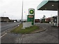
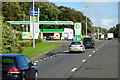
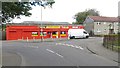
Kingsway West at Dundee
The A90 Dundee ring road, with all essentials - fuel, cafe, hotel.
Image: © M J Richardson
Taken: 27 Feb 2010
0.20 miles
8
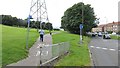
South Road Park
Path leaving Arran Drive.
Image: © Richard Webb
Taken: 30 Aug 2014
0.21 miles
9
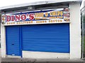
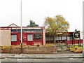
Charleston Supersavers
Shop on Dunholm Road, Charleston.
Image: © Richard Webb
Taken: 30 Aug 2014
0.22 miles
10
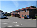
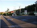
Motel off Kingsway West in Dundee
Part of a complex of hotel, restaurant and filling station.
Image: © James Denham
Taken: 31 May 2010
0.22 miles