IMAGES TAKEN NEAR TO
Forth Crescent, DUNDEE, DD2 4JB
Introduction
This page details the photographs taken nearby to Forth Crescent, DD2 4JB by members of the Geograph project.
The Geograph project started in 2005 with the aim of publishing, organising and preserving representative images for every square kilometre of Great Britain, Ireland and the Isle of Man.

There are currently over 7.5m images from over14,400 individuals and you can help contribute to the project by visiting https://www.geograph.org.uk
Image Map
Images are licensed for reuse under creativecommons.org/licenses/by-sa/2.0
Notes
- Clicking on the map will re-center to the selected point.
- The higher the marker number, the further away the image location is from the centre of the postcode.
Image Listing (14 Images Found)
Images are licensed for reuse under creativecommons.org/licenses/by-sa/2.0
Image
Details
Distance
1
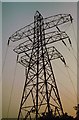
Electricity Pylons in Dundee
Taken on a winter's evening.
Image: © Duncan David McColl
Taken: Unknown
0.09 miles
2
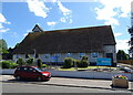
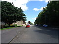
Menzieshill Parish Church
On Charleston Drive.
Image: © JThomas
Taken: 12 Jun 2021
0.11 miles
3
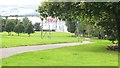
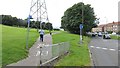
South Road Park
Path to the superstore. A park in northern Dundee.
Image: © Richard Webb
Taken: 30 Aug 2014
0.11 miles
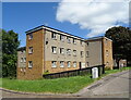
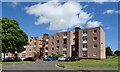
7
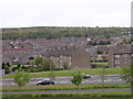
Charleston, Dundee
Post war local authority housing. The view is taken from the centre of the square looking northwards.
Image: © Val Vannet
Taken: 16 May 2005
0.18 miles
8
South Road Park
Path leaving Arran Drive.
Image: © Richard Webb
Taken: 30 Aug 2014
0.18 miles
10
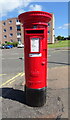
Elizabethan postbox on Dickson Avenue, Dundee
Postbox No. DD2 165.
See Image] for context.
Image: © JThomas
Taken: 12 Jun 2021
0.20 miles