IMAGES TAKEN NEAR TO
Dochart Terrace, DUNDEE, DD2 4EX
Introduction
This page details the photographs taken nearby to Dochart Terrace, DD2 4EX by members of the Geograph project.
The Geograph project started in 2005 with the aim of publishing, organising and preserving representative images for every square kilometre of Great Britain, Ireland and the Isle of Man.

There are currently over 7.5m images from over14,400 individuals and you can help contribute to the project by visiting https://www.geograph.org.uk
Image Map
Images are licensed for reuse under creativecommons.org/licenses/by-sa/2.0
Notes
- Clicking on the map will re-center to the selected point.
- The higher the marker number, the further away the image location is from the centre of the postcode.
Image Listing (10 Images Found)
Images are licensed for reuse under creativecommons.org/licenses/by-sa/2.0
Image
Details
Distance
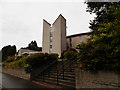
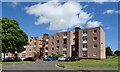
4
Menzieshill Parish Church
On Charleston Drive.
Image: © JThomas
Taken: 12 Jun 2021
0.20 miles
5
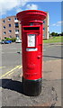
Elizabethan postbox on Dickson Avenue, Dundee
Postbox No. DD2 165.
See Image] for context.
Image: © JThomas
Taken: 12 Jun 2021
0.20 miles

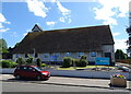
7
Spar Shop, Orleans Place, Dundee
Showing position of Postbox No. DD2 165.
See Image] for postbox.
Image: © JThomas
Taken: 12 Jun 2021
0.21 miles
8
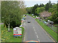
Ninewells Drive, Dundee
Road heading to Ninewells Hospital, viewed from the footbridge.
Image: © Scott Cormie
Taken: 18 May 2021
0.23 miles