IMAGES TAKEN NEAR TO
Glamis Drive, DUNDEE, DD2 1QN
Introduction
This page details the photographs taken nearby to Glamis Drive, DD2 1QN by members of the Geograph project.
The Geograph project started in 2005 with the aim of publishing, organising and preserving representative images for every square kilometre of Great Britain, Ireland and the Isle of Man.

There are currently over 7.5m images from over14,400 individuals and you can help contribute to the project by visiting https://www.geograph.org.uk
Image Map
Images are licensed for reuse under creativecommons.org/licenses/by-sa/2.0
Notes
- Clicking on the map will re-center to the selected point.
- The higher the marker number, the further away the image location is from the centre of the postcode.
Image Listing (6 Images Found)
Images are licensed for reuse under creativecommons.org/licenses/by-sa/2.0
Image
Details
Distance
2
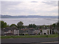
Tay estuary from near Ninewells hospital
Many wards in the adjacent Ninewells hospital enjoy up estuary views like this.
Image: © Val Vannet
Taken: 17 May 2005
0.15 miles
3
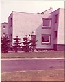
Student Accommodation.
As was then quite new in 1975, student housing in the grounds of Ninewells Hospital.
Image: © Chris Eaton
Taken: 3 Aug 1975
0.19 miles
4
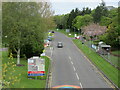
Ninewells Drive, Dundee
Road heading to Ninewells Hospital, viewed from the footbridge.
Image: © Scott Cormie
Taken: 18 May 2021
0.21 miles
5
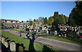
Balgay cemetery, Dundee
The old cemetery was extended in the 1970's. By the 1980's all places were allocated and a new cemetery was opened at nearby Birkhill.
Image: © Dan
Taken: 11 Feb 2009
0.24 miles
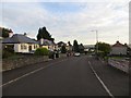
6
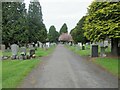
Balgay Cemetery
Balgay Cemetery in the western part of Dundee, looking westwards towards Glamis Road.
Image: © Scott Cormie
Taken: 18 May 2021
0.24 miles