IMAGES TAKEN NEAR TO
Hazel Avenue, DUNDEE, DD2 1QD
Introduction
This page details the photographs taken nearby to Hazel Avenue, DD2 1QD by members of the Geograph project.
The Geograph project started in 2005 with the aim of publishing, organising and preserving representative images for every square kilometre of Great Britain, Ireland and the Isle of Man.

There are currently over 7.5m images from over14,400 individuals and you can help contribute to the project by visiting https://www.geograph.org.uk
Image Map
Images are licensed for reuse under creativecommons.org/licenses/by-sa/2.0
Notes
- Clicking on the map will re-center to the selected point.
- The higher the marker number, the further away the image location is from the centre of the postcode.
Image Listing (7 Images Found)
Images are licensed for reuse under creativecommons.org/licenses/by-sa/2.0
Image
Details
Distance
1
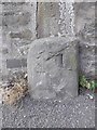
Old Milestone by Perth Road, Dundee parish
Stone post by the UC road, in parish of Dundee (City of Dundee District), Perth Road, in pavement by stone wall opposite River Crescent.
Surveyed
Milestone Society National ID: CD_DDPT02
Image: © Milestone Society
Taken: Unknown
0.18 miles
3
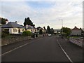
Student Accommodation.
As was then quite new in 1975, student housing in the grounds of Ninewells Hospital.
Image: © Chris Eaton
Taken: 3 Aug 1975
0.22 miles
6
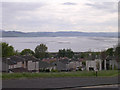
Tay estuary from near Ninewells hospital
Many wards in the adjacent Ninewells hospital enjoy up estuary views like this.
Image: © Val Vannet
Taken: 17 May 2005
0.23 miles
7
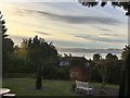
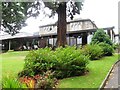
Hotel garden with a view over the Firth of Tay
The Best Western Invercarse Hotel
Image: © Graham Hogg
Taken: 14 Oct 2019
0.25 miles