IMAGES TAKEN NEAR TO
Hyndford Street, DUNDEE, DD2 1HX
Introduction
This page details the photographs taken nearby to Hyndford Street, DD2 1HX by members of the Geograph project.
The Geograph project started in 2005 with the aim of publishing, organising and preserving representative images for every square kilometre of Great Britain, Ireland and the Isle of Man.

There are currently over 7.5m images from over14,400 individuals and you can help contribute to the project by visiting https://www.geograph.org.uk
Image Map
Images are licensed for reuse under creativecommons.org/licenses/by-sa/2.0
Notes
- Clicking on the map will re-center to the selected point.
- The higher the marker number, the further away the image location is from the centre of the postcode.
Image Listing (5 Images Found)
Images are licensed for reuse under creativecommons.org/licenses/by-sa/2.0
Image
Details
Distance
1

Victoria Gardens
The Victoria Garden is the latest project of the Dundee-based charity, Yusuf Youth Initiative.
This was the site of a bowling green, and the old clubhouse has been put to good use as a shop and storage space.
Image: © Dave Croker
Taken: 24 Jun 2023
0.21 miles
2

Town Houses
On Perth Road. The cladding is attractive now, but I wonder how it will weather?
Image: © M J Richardson
Taken: 3 Sep 2009
0.21 miles
3
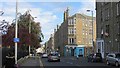
Blackness Road
Descent towards the city centre.
Image: © Richard Webb
Taken: 30 Aug 2014
0.22 miles
4

The top of Logie Estate, Dundee
The walled structure houses a memorial which celebrates the fact that Logie was the first housing scheme of its type when it was built in 1919 - 1920
Image: © Elliott Simpson
Taken: 12 May 2009
0.24 miles
5

Balgay Road
A wide street with Victoria Park on the right.
Image: © Richard Webb
Taken: 30 Aug 2014
0.24 miles