IMAGES TAKEN NEAR TO
Roseangle, DUNDEE, DD1 4LP
Introduction
This page details the photographs taken nearby to Roseangle, DD1 4LP by members of the Geograph project.
The Geograph project started in 2005 with the aim of publishing, organising and preserving representative images for every square kilometre of Great Britain, Ireland and the Isle of Man.

There are currently over 7.5m images from over14,400 individuals and you can help contribute to the project by visiting https://www.geograph.org.uk
Image Map
Images are licensed for reuse under creativecommons.org/licenses/by-sa/2.0
Notes
- Clicking on the map will re-center to the selected point.
- The higher the marker number, the further away the image location is from the centre of the postcode.
Image Listing (101 Images Found)
Images are licensed for reuse under creativecommons.org/licenses/by-sa/2.0
Image
Details
Distance
1

Perth Road, Dundee
View from near The Gate Church international towards the spire of St John's (1884; architect James Hutton). Dundee University campus is to the left.
Image: © Stanley Howe
Taken: 1 Sep 2007
0.01 miles
2

St. John's Church, Dundee
Opened in 1884 and designed by James Hutton.
Image: © Dan
Taken: 11 Feb 2009
0.01 miles
3

Towards St John's Church Dundee
Taken from the gardens at Seabraes. See Image
Image: © Douglas Nelson
Taken: 28 Sep 2012
0.02 miles
4
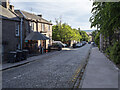
Roseangle, Dundee
Street running south from Perth Road, Dundee.
Image: © Rossographer
Taken: 5 Jun 2022
0.02 miles
5
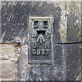
Flush Bracket, Dundee
Flush bracket bench mark on the south-east face of St John's Church Image at Roseangle, Dundee.
The number on the bracket is G887 and it was originally levelled to 61.786 feet above Newlyn datum.
Further details at https://www.bench-marks.org.uk/bm17800 .
Image: © Rossographer
Taken: 5 Jun 2022
0.03 miles
7
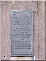
Tree of Liberty
This plaque is on the wall to the west of the Duncan of Jordanstone College of Art & Design and relates to local unrest during the time of the French Revolution.
Image: © Elliott Simpson
Taken: 3 Mar 2009
0.04 miles
8
Stepping down
Steps leading down from Perth road to Greenmarket. The riverside Tesco and river Tay visible in the background.
Image: © Dan
Taken: 11 Feb 2009
0.05 miles
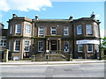
10

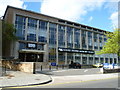
Airlie Place, Dundee
Built ca. 1850 as bourgeoise residences and now offices for the University of Dundee and B-listed: http://www.britishlistedbuildings.co.uk/sc-25341-airlie-place-1-15-odd-numbers-airlie-hall .
Image: © Bill Harrison
Taken: 13 Apr 2013
0.08 miles