1
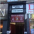
St David's Halls, Dundee
St David’s Halls (at rear of 84-90 Nethergate), together with Gardyne's House http://www.geograph.org.uk/photo/3135694 , 70-73 High Street, Dundee, is the only pre-1700 secular building in the burgh. Built in the early 17th century, the upper floors were rebuilt in the 18th century. It is near the site of Earl Crawford's 15th century lodging which is probably beneath the Nethergate Centre which towers over St David’s Halls to the east.
Image: © Douglas Nelson
Taken: 18 May 2016
0.00 miles
2
Lodge St David No 78
Dundee city centre.
Image: © Richard Webb
Taken: 8 Dec 2018
0.01 miles
3
Information on the cross
The information sign on the base of the town cross in Dundee.
Image: © Bill Nicholls
Taken: 29 Mar 2010
0.02 miles
4
High Street
Dundee city centre.
Image: © Richard Webb
Taken: 30 Aug 2014
0.02 miles
5
Mecca Playhouse in the Nethergate
A late-1960s bingo hall on the site of Green's Playhouse cinema (1936). After a serious fire in 1995 only the advertising tower survived (now stripped of its cladding from the 1970s rebuild). The tower is Grade-B listed.
Image: © kim traynor
Taken: 22 May 2011
0.02 miles
6
Mecca Playhouse Tower, Nethergate
The tower seems to serve no other purpose than to advertise itself.
Image: © kim traynor
Taken: 22 May 2011
0.02 miles
7
Old burgh cross, Nethergate
According to its plaque, the shaft of the old Dundee Cross was erected in 1586 near the Tolbooth in Market-Gait, then moved to this spot and re-erected on its new base in 1874.
Image: © kim traynor
Taken: 22 May 2011
0.02 miles
8
Old Central Cross - moved to High Street, Dundee
Town Cross, old shaft by the UC road, in parish of Dundee (City Of Dundee District), High Street, Dundee, in pedestrian precinct.
Grade B(S) listed.
Reference: LB25386 http://portal.historicenvironment.scot/designation/LB25386
To be surveyed
Milestone Society National ID: CD_DUN
Image: © Milestone Society
Taken: Unknown
0.03 miles
9
Market Cross
Located near St Mary's Tower
Image: © Gordon Czeschel
Taken: 17 Sep 2005
0.03 miles
10
Mercat Cross, Dundee
Dundee Mercat Cross with the City Churches' in the background.
Image: © Euan Nelson
Taken: 6 May 2012
0.03 miles


