IMAGES TAKEN NEAR TO
Thorter Row, DUNDEE, DD1 3BX
Introduction
This page details the photographs taken nearby to Thorter Row, DD1 3BX by members of the Geograph project.
The Geograph project started in 2005 with the aim of publishing, organising and preserving representative images for every square kilometre of Great Britain, Ireland and the Isle of Man.

There are currently over 7.5m images from over14,400 individuals and you can help contribute to the project by visiting https://www.geograph.org.uk
Image Map
Images are licensed for reuse under creativecommons.org/licenses/by-sa/2.0
Notes
- Clicking on the map will re-center to the selected point.
- The higher the marker number, the further away the image location is from the centre of the postcode.
Image Listing (376 Images Found)
Images are licensed for reuse under creativecommons.org/licenses/by-sa/2.0
Image
Details
Distance
1
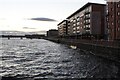
From The Tay Bridge
Looking towards Dundee's modern waterfront properties from the Tay Road Bridge on a chilly November morning. Viewed from outside the square.
Image: © Mary and Angus Hogg
Taken: 18 Nov 2018
0.03 miles
2
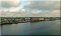
Marine Parade, Dundee
The former quayside at Marine Parade in Dundee, currently being redeveloped. The Tay Road Bridge dominates to the right.
Image: © Rossographer
Taken: 6 Jun 2022
0.03 miles
4

The "90 ton crane", Victoria Docks, Dundee
This steam driven crane was one of the most powerful in its day. I recall as a kid seeing it lifting railway wagons of potatoes from the railway track - see http://photopolis.dundeecity.gov.uk/wc0796.htm - and swing them over a cargo ship which, I was told, was taking the potatoes to Eastern Europe for Vodka production.
This photo was taken just before the crane was demolished in the 1970s and the gentleman in the foreground was doing a pen and ink sketch of it.
Image: © Elliott Simpson
Taken: Unknown
0.04 miles
5
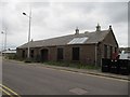
Remaining building
One of the few remaining dock buildings left at the old Dundee docks. This one is along South Victoria Dock road.
Image: © Bill Nicholls
Taken: 28 Aug 2010
0.04 miles
6
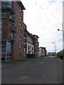
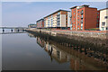
South Victoria Dock Road
Looking along South Victoria dock road towards the Tay Road Bridge end.
Image: © Bill Nicholls
Taken: 10 Apr 2010
0.04 miles
7
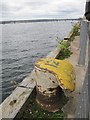
Bollard by the dock
One of the old bollards the ships used to tie up to on the old disused dock just off South Victoria dock road.
Image: © Bill Nicholls
Taken: 28 Aug 2010
0.04 miles
8
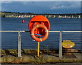
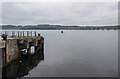
Lifebuoy on the Queen Elizabeth Wharf, Dundee
In the distance is the Tay Road Bridge.
The Tay Road Bridge carries the A92 road across the Firth of Tay from Newport-on-Tay in Fife to Dundee in Scotland. The bridge was opened in 1966, and is 2,250 metres (1.4 miles) in length. A pedestrian walkway runs along the centre of the bridge, with a lift at the Dundee end.
Image: © Mat Fascione
Taken: 25 Jun 2017
0.04 miles