IMAGES TAKEN NEAR TO
Dudhope Street, DUNDEE, DD1 1JS
Introduction
This page details the photographs taken nearby to Dudhope Street, DD1 1JS by members of the Geograph project.
The Geograph project started in 2005 with the aim of publishing, organising and preserving representative images for every square kilometre of Great Britain, Ireland and the Isle of Man.

There are currently over 7.5m images from over14,400 individuals and you can help contribute to the project by visiting https://www.geograph.org.uk
Image Map
Images are licensed for reuse under creativecommons.org/licenses/by-sa/2.0
Notes
- Clicking on the map will re-center to the selected point.
- The higher the marker number, the further away the image location is from the centre of the postcode.
Image Listing (209 Images Found)
Images are licensed for reuse under creativecommons.org/licenses/by-sa/2.0
Image
Details
Distance
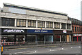
5
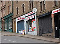
The Hilltown Dundee
Shops on the steep hill know as the Hilltown which runs from Victoria Road up to the Hilltown Clock Image
Image: © Paul Mc Ilroy
Taken: 28 Feb 2009
0.04 miles
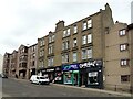
7
Victoria Road (A929), Dundee
The red business is the Ladywell Tavern public house.
Image: © JThomas
Taken: 10 Jun 2021
0.05 miles
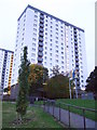
8
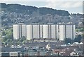
Dundee - Hilltown Flats
Landmark tall buildings in central Dundee, between The Law and the city centre.
www.dundeecity.gov.uk
Image: © Colin Smith
Taken: 2 Jun 2017
0.06 miles
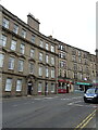
10
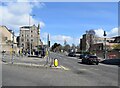
Junction of Hilltown (to the left) and Victoria Road (the A929)
The building with the bartizan (corner tower) was once a "calendering, bag sewing and finishing works" according to its B-listing (LB25122: http://portal.historicenvironment.scot/designation/LB25122 ). Part of the wellgate Centre can be seen to the right.
Image: © Bill Harrison
Taken: 9 Apr 2022
0.08 miles