IMAGES TAKEN NEAR TO
Clyde Court, Cliffburn Road, ARBROATH, DD11 5TE
Introduction
This page details the photographs taken nearby to Clyde Court, Cliffburn Road, DD11 5TE by members of the Geograph project.
The Geograph project started in 2005 with the aim of publishing, organising and preserving representative images for every square kilometre of Great Britain, Ireland and the Isle of Man.

There are currently over 7.5m images from over14,400 individuals and you can help contribute to the project by visiting https://www.geograph.org.uk
Image Map
Images are licensed for reuse under creativecommons.org/licenses/by-sa/2.0
Notes
- Clicking on the map will re-center to the selected point.
- The higher the marker number, the further away the image location is from the centre of the postcode.
Image Listing (24 Images Found)
Images are licensed for reuse under creativecommons.org/licenses/by-sa/2.0
Image
Details
Distance
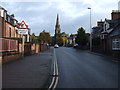
1
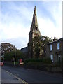
St Mary the Virgin Scottish Episcopal Church
Image: © JThomas
Taken: 23 Oct 2013
0.09 miles
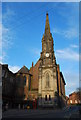
3
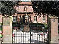
Arbroath Library
Abroath Library and Art Gallery with statue of Robert Burns in front.
Image: © Duncan David McColl
Taken: 24 Aug 2008
0.11 miles
4
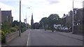
Springfield Terrace, Arbroath
I enjoyed the lack of on street parked cars - looks long ago.
Image: © Richard Webb
Taken: 27 Aug 2016
0.11 miles
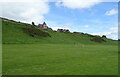
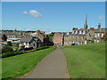
6
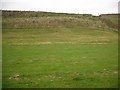
Steep slope, Victoria Park
Steep slopes, a former sea cliff, falling to a raised beach. Taken from the road running along the raised beach.
Image: © Richard Webb
Taken: 21 Sep 2009
0.13 miles