IMAGES TAKEN NEAR TO
Inverkeilor, ARBROATH, DD11 5SN
Introduction
This page details the photographs taken nearby to DD11 5SN by members of the Geograph project.
The Geograph project started in 2005 with the aim of publishing, organising and preserving representative images for every square kilometre of Great Britain, Ireland and the Isle of Man.

There are currently over 7.5m images from over14,400 individuals and you can help contribute to the project by visiting https://www.geograph.org.uk
Image Map
Images are licensed for reuse under creativecommons.org/licenses/by-sa/2.0
Notes
- Clicking on the map will re-center to the selected point.
- The higher the marker number, the further away the image location is from the centre of the postcode.
Image Listing (9 Images Found)
Images are licensed for reuse under creativecommons.org/licenses/by-sa/2.0
Image
Details
Distance
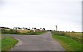
1
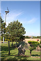
Contradictory Winds
If look carefully at the small red windmill on the fence, and compare its orientation with that of the turbine on the left, you can see that the turbine is facing east and the windmill is facing south!
Image: © Anne Burgess
Taken: 5 Aug 2014
0.09 miles
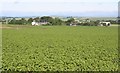
2
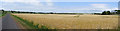
Field of Barley
A field beside the unfenced road near Ethie Greens.
Image: © Anne Burgess
Taken: 5 Jul 2018
0.15 miles
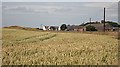
3
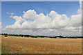
Looking towards Raesmill
That's an interesting sky above the barley field. There's a sea breeze from the left, and the unbroken blue sky has come to an abrupt end here where the sea breeze is being deflected upwards on meeting the land breeze from the right, pushing the clouds up into a concave front along the convergence.
Image: © Anne Burgess
Taken: 3 Aug 2021
0.18 miles
4
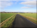
Unfenced Road
The road to Ethie looking back to Raesmill.
Image: © Scott Cormie
Taken: 27 Dec 2017
0.18 miles
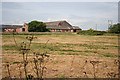
6
Raesmill
Raesmill is the farm in the left middle distance, seen across some of its surrounding arable land.
Image: © Anne Burgess
Taken: 20 Jun 2006
0.21 miles
7
North Mains of Ethie
Looking over a field of wheat towards the derelict steading and restored cottage at North Mains.
Image: © Anne Burgess
Taken: 28 Jul 2006
0.23 miles
8
North Mains of Ethie
This derelict steading was formerly the heart of a large dairy farm.
Image: © Anne Burgess
Taken: 28 Jul 2006
0.23 miles
9
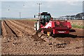
Ethie Barns
This machine is preparing the furrows by sieving out the stones and large clods from each bed, leaving a fine tilth in which to plant seed potatoes.
Image: © Anne Burgess
Taken: 7 Apr 2007
0.24 miles