IMAGES TAKEN NEAR TO
Main Road, ARBROATH, DD11 5RN
Introduction
This page details the photographs taken nearby to Main Road, DD11 5RN by members of the Geograph project.
The Geograph project started in 2005 with the aim of publishing, organising and preserving representative images for every square kilometre of Great Britain, Ireland and the Isle of Man.

There are currently over 7.5m images from over14,400 individuals and you can help contribute to the project by visiting https://www.geograph.org.uk
Image Map
Images are licensed for reuse under creativecommons.org/licenses/by-sa/2.0
Notes
- Clicking on the map will re-center to the selected point.
- The higher the marker number, the further away the image location is from the centre of the postcode.
Image Listing (32 Images Found)
Images are licensed for reuse under creativecommons.org/licenses/by-sa/2.0
Image
Details
Distance
1
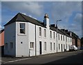
Main Road
18th century houses in the main street of Inverkeilor. This was originally the main road from Arbroath to Montrose and Aberdeen, but the village was bypassed in the lat 20th century.
Image: © Anne Burgess
Taken: 5 Jun 2017
0.01 miles
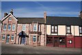
2
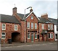
The Chance Inn, Main Road
Not trading at the time of our visit.
Image: © Graham Hogg
Taken: 15 May 2014
0.02 miles
3
Chance Inn, Inverkeilor
Sadly, now closed and up for sale.
Image: © Douglas Nelson
Taken: 22 Aug 2015
0.02 miles
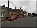
4
The Chance Inn
In the centre of Inverkeilor
Image: © Dominic Dawn Harry and Jacob Paterson
Taken: 23 Dec 2005
0.05 miles
6
Gordon's Restaurant
Gordon's restaurant is next to the pub (Inn) in the village of Inverkeilor.
Image: © Duncan David McColl
Taken: 21 Aug 2005
0.05 miles
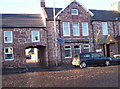
7
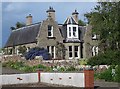
12 Station Road
My eye was first caught by the splendid blue ceanothus bush, and then by the elaborate twin Dutch gables and central windows. The house is on the second edition of the six-inch Ordnance Survey map, but not the first edition, so it must be late Victorian.
Image: © Anne Burgess
Taken: 5 Jun 2017
0.10 miles
8
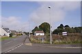
Vacant site, Inverkeilor
Some houses were built here around 2005 but this area was not built upon. The white building is a telephone exchange.
Image: © Richard Webb
Taken: 23 Sep 2017
0.10 miles
9
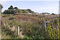
Awaiting development, Inverkeilor
Some houses were built here about 10 years earlier but this area, now weed covered has not changed much since the first Streetview images in 2008.
Image: © Richard Webb
Taken: 23 Sep 2017
0.10 miles
10
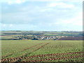
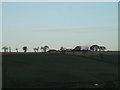
Inverkeilor
Taken from the hill on the other side of the Lunan Water near to Arbikie farm
Image: © Alan Thomson
Taken: 20 Feb 2006
0.11 miles