IMAGES TAKEN NEAR TO
ARBROATH, DD11 5RL
Introduction
This page details the photographs taken nearby to DD11 5RL by members of the Geograph project.
The Geograph project started in 2005 with the aim of publishing, organising and preserving representative images for every square kilometre of Great Britain, Ireland and the Isle of Man.

There are currently over 7.5m images from over14,400 individuals and you can help contribute to the project by visiting https://www.geograph.org.uk
Image Map
Images are licensed for reuse under creativecommons.org/licenses/by-sa/2.0
Notes
- Clicking on the map will re-center to the selected point.
- The higher the marker number, the further away the image location is from the centre of the postcode.
Image Listing (6 Images Found)
Images are licensed for reuse under creativecommons.org/licenses/by-sa/2.0
Image
Details
Distance
1
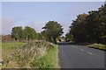
A92, Inverkeilor
Heading northwards with the railway on the left, across a narrow field.
Image: © Richard Webb
Taken: 23 Sep 2017
0.03 miles
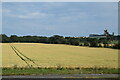
2
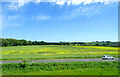
A92 near Inverkeilor
An oilseed rape crop beyond.
Image: © JThomas
Taken: 13 Jun 2021
0.10 miles
3
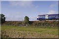
Aberdeen to Dundee railway, Inverkeilor
Crossing an embankment south of Inverkeilor. The train left Aberdeen at 1038, bound for Glasgow.
Image: © Richard Webb
Taken: 23 Sep 2017
0.11 miles
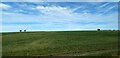
6
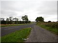
A92 Lay-by close to the Railway Line
Closest town is Inverkeilor.
Image: © James Emmans
Taken: 14 Sep 2016
0.22 miles