IMAGES TAKEN NEAR TO
ARBROATH, DD11 5RG
Introduction
This page details the photographs taken nearby to DD11 5RG by members of the Geograph project.
The Geograph project started in 2005 with the aim of publishing, organising and preserving representative images for every square kilometre of Great Britain, Ireland and the Isle of Man.

There are currently over 7.5m images from over14,400 individuals and you can help contribute to the project by visiting https://www.geograph.org.uk
Image Map
Images are licensed for reuse under creativecommons.org/licenses/by-sa/2.0
Notes
- Clicking on the map will re-center to the selected point.
- The higher the marker number, the further away the image location is from the centre of the postcode.
Image Listing (5 Images Found)
Images are licensed for reuse under creativecommons.org/licenses/by-sa/2.0
Image
Details
Distance
2
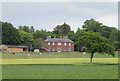
Parkhill House
A long view across the fields from the Cadgers' Road. Parkhill House was built in 1804 for Alexander Duncan, who had bought the property when he retired from the East India Company in 1799. It was altered in 1905/7 and remained in the Duncan family until 2013. It is a Category B Listed building. Alexander Duncan was a keen plant collector and he also established a walled garden, and the sundial there is Category C Listed.
Image: © Anne Burgess
Taken: 4 Jun 2017
0.18 miles
3
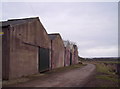
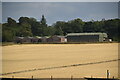
Tattie Sheds at Parkhill Farm
Image: © Dominic Dawn Harry and Jacob Paterson
Taken: 25 Jan 2006
0.19 miles
4
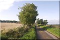
Yellow road, Parkhill
Starting to grow a central grass strip.
Image: © Richard Webb
Taken: 23 Sep 2017
0.23 miles
5
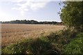
Stubble, Mains of Parkhill
Angus arable.
Image: © Richard Webb
Taken: 23 Sep 2017
0.24 miles