IMAGES TAKEN NEAR TO
ARBROATH, DD11 5RA
Introduction
This page details the photographs taken nearby to DD11 5RA by members of the Geograph project.
The Geograph project started in 2005 with the aim of publishing, organising and preserving representative images for every square kilometre of Great Britain, Ireland and the Isle of Man.

There are currently over 7.5m images from over14,400 individuals and you can help contribute to the project by visiting https://www.geograph.org.uk
Image Map
Images are licensed for reuse under creativecommons.org/licenses/by-sa/2.0
Notes
- Clicking on the map will re-center to the selected point.
- The higher the marker number, the further away the image location is from the centre of the postcode.
Image Listing (6 Images Found)
Images are licensed for reuse under creativecommons.org/licenses/by-sa/2.0
Image
Details
Distance
1

Tulip, Silverwells Garden Centre
A close up of a tulip after a heavy shower of rain.
Image: © Gwen and James Anderson
Taken: 16 May 2009
0.01 miles
2

Tulips, Silverwells Garden Centre
Tulips after a heavy shower of rain.
Image: © Gwen and James Anderson
Taken: 16 May 2009
0.02 miles
3
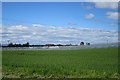
Near Bearfauld
Polytunnels for soft fruit beyond a field of cereals.
Image: © Anne Burgess
Taken: 7 Jun 2017
0.17 miles
4
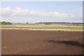
Seedbed outside Arbroath
Arable farming beside the A92.
Image: © Richard Webb
Taken: 23 Sep 2017
0.19 miles
5
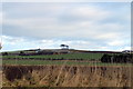
View of Dickmount Law
The trees pinpoint Dickmount Law. In the nearer foreground is Dickmontlaw Farm and open farmland in the immediate foreground
Image: © Alan Morrison
Taken: 6 Feb 2009
0.22 miles
6
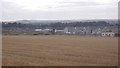
Earl Matthew Avenue
New houses being built on the edge of Arbroath.
Image: © Richard Webb
Taken: 27 Aug 2016
0.24 miles