IMAGES TAKEN NEAR TO
Earl Matthew Avenue, ARBROATH, DD11 5JU
Introduction
This page details the photographs taken nearby to Earl Matthew Avenue, DD11 5JU by members of the Geograph project.
The Geograph project started in 2005 with the aim of publishing, organising and preserving representative images for every square kilometre of Great Britain, Ireland and the Isle of Man.

There are currently over 7.5m images from over14,400 individuals and you can help contribute to the project by visiting https://www.geograph.org.uk
Image Map
Images are licensed for reuse under creativecommons.org/licenses/by-sa/2.0
Notes
- Clicking on the map will re-center to the selected point.
- The higher the marker number, the further away the image location is from the centre of the postcode.
Image Listing (13 Images Found)
Images are licensed for reuse under creativecommons.org/licenses/by-sa/2.0
Image
Details
Distance
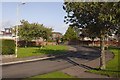
1
Earl Matthew Avenue
New houses being built on the edge of Arbroath.
Image: © Richard Webb
Taken: 27 Aug 2016
0.09 miles
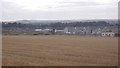
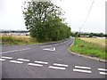
2
Near Bearfauld
Polytunnels for soft fruit beyond a field of cereals.
Image: © Anne Burgess
Taken: 7 Jun 2017
0.16 miles
4

Tulips, Silverwells Garden Centre
Tulips after a heavy shower of rain.
Image: © Gwen and James Anderson
Taken: 16 May 2009
0.17 miles
5

Tulip, Silverwells Garden Centre
A close up of a tulip after a heavy shower of rain.
Image: © Gwen and James Anderson
Taken: 16 May 2009
0.18 miles
7
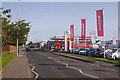
Montrose Road
Garage and car showroom on the A92. Fuel was £1.22 for a litre of diesel and £1.23 for petrol.
Image: © Richard Webb
Taken: 23 Sep 2017
0.20 miles
8
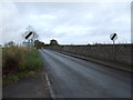
Seaton Road
Heading north on National Cycle Route 1 .
Image: © JThomas
Taken: 23 Oct 2013
0.21 miles
9
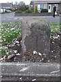
Old Milestone by the A92, Arbroath, Arbroath and St Vigeans parish
Stone post by the A92, in parish of Arbroath and St Vigeans (Angus District), North end of Arbroath, near Pedestrian crossing, near Ethie Place.
Inscription once read:-
: (Montrose 11¾) : : (Arbroath 1) :
Surveyed
Milestone Society National ID: AN_ARMN01
Image: © Milestone Society
Taken: Unknown
0.22 miles