IMAGES TAKEN NEAR TO
Montrose Road, ARBROATH, DD11 5JT
Introduction
This page details the photographs taken nearby to Montrose Road, DD11 5JT by members of the Geograph project.
The Geograph project started in 2005 with the aim of publishing, organising and preserving representative images for every square kilometre of Great Britain, Ireland and the Isle of Man.

There are currently over 7.5m images from over14,400 individuals and you can help contribute to the project by visiting https://www.geograph.org.uk
Image Map
Images are licensed for reuse under creativecommons.org/licenses/by-sa/2.0
Notes
- Clicking on the map will re-center to the selected point.
- The higher the marker number, the further away the image location is from the centre of the postcode.
Image Listing (6 Images Found)
Images are licensed for reuse under creativecommons.org/licenses/by-sa/2.0
Image
Details
Distance
1
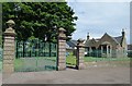
Gates and Gate Lodge
This is the entrance to Arbroath's Eastern Cemetery. It was opened in 1894.
Image: © Anne Burgess
Taken: 4 Jun 2017
0.15 miles
3
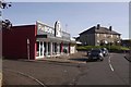
Pie Bob's Bakery
On Grant Road, Arbroath.
Image: © Richard Webb
Taken: 23 Sep 2017
0.22 miles
4
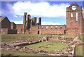
Arbroath Abbey
Arbroath Abbey has an important place in the history of Scotland; the Declaration of Independence was signed here on 6 April 1320
Image: © Anne Burgess
Taken: Unknown
0.23 miles
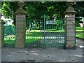
5
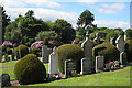
Eastern Cemetery
Opened in 1894, the cemetery contains over 15,000 burials.
Image: © Anne Burgess
Taken: 7 Jun 2017
0.24 miles
6
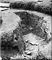
Souterrain at the Eastern Cemetery, Arbroath
This souterrain is sadly no longer visible as it was backfilled sometime after this photograph was taken in 1976. https://canmore.org.uk/site/35545/arbroath-eastern-cemetery
Image: © Sandy Gerrard
Taken: Unknown
0.25 miles