IMAGES TAKEN NEAR TO
Cliffburn Road, ARBROATH, DD11 5BA
Introduction
This page details the photographs taken nearby to Cliffburn Road, DD11 5BA by members of the Geograph project.
The Geograph project started in 2005 with the aim of publishing, organising and preserving representative images for every square kilometre of Great Britain, Ireland and the Isle of Man.

There are currently over 7.5m images from over14,400 individuals and you can help contribute to the project by visiting https://www.geograph.org.uk
Image Map
Images are licensed for reuse under creativecommons.org/licenses/by-sa/2.0
Notes
- Clicking on the map will re-center to the selected point.
- The higher the marker number, the further away the image location is from the centre of the postcode.
Image Listing (16 Images Found)
Images are licensed for reuse under creativecommons.org/licenses/by-sa/2.0
Image
Details
Distance
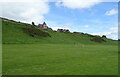
3
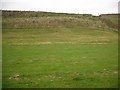
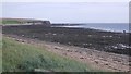
Steep slope, Victoria Park
Steep slopes, a former sea cliff, falling to a raised beach. Taken from the road running along the raised beach.
Image: © Richard Webb
Taken: 21 Sep 2009
0.15 miles
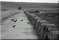
4

Flying High
A group of oystercatchers flying overhead.
Image: © Karen Vernon
Taken: 17 Feb 2010
0.16 miles
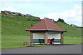
5
Victoria Park Promenade, Arbroath
Out of season
Image: © Donald MacDonald
Taken: 16 Nov 2010
0.17 miles
6
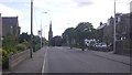
Springfield Terrace, Arbroath
I enjoyed the lack of on street parked cars - looks long ago.
Image: © Richard Webb
Taken: 27 Aug 2016
0.18 miles
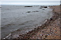
7
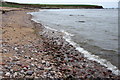
Beach off Victoria Park
A rocky beach north of Arbroath.
Image: © Richard Webb
Taken: 27 Aug 2016
0.18 miles
8
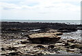
Beach below Victoria Park, Arbroath
Very little of this square is visible at high tide.
Image: © Mike Pennington
Taken: 13 Jul 2013
0.20 miles
10
Beach below Victoria Park, Arbroath
Very little of this square is visible at high tide.
Image: © Mike Pennington
Taken: 13 Jul 2013
0.21 miles