IMAGES TAKEN NEAR TO
Friockheim, ARBROATH, DD11 4XB
Introduction
This page details the photographs taken nearby to DD11 4XB by members of the Geograph project.
The Geograph project started in 2005 with the aim of publishing, organising and preserving representative images for every square kilometre of Great Britain, Ireland and the Isle of Man.

There are currently over 7.5m images from over14,400 individuals and you can help contribute to the project by visiting https://www.geograph.org.uk
Image Map
Images are licensed for reuse under creativecommons.org/licenses/by-sa/2.0
Notes
- Clicking on the map will re-center to the selected point.
- The higher the marker number, the further away the image location is from the centre of the postcode.
Image Listing (5 Images Found)
Images are licensed for reuse under creativecommons.org/licenses/by-sa/2.0
Image
Details
Distance
1
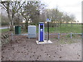
Electric car charging point, Friockheim
Single electric car charging point in the recreation ground car park on the east side of Friockheim.
Image: © Scott Cormie
Taken: 14 Apr 2019
0.03 miles
2
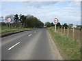
B965 approaching Friockheim
The B965 heading west towards Friockheim.
Image: © Scott Cormie
Taken: 14 Apr 2019
0.13 miles
3
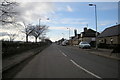
Gardyne Street, Friockheim near its junction with Union Street
Picture taken looking west.
Image: © Alan Morrison
Taken: 5 Mar 2009
0.18 miles
4
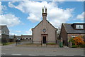
Masonic Lodge, Friockheim, Angus
The Bruce No.593, Masonic Lodge Gardyne Street, Friockheim, DD11 4SP.
Image: © Jim Campbell
Taken: 15 May 2010
0.18 miles
5
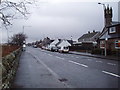
Gardyne Street, Friockheim
At the eastern end of Friockheim
Image: © Douglas Nelson
Taken: 4 Jan 2018
0.18 miles