IMAGES TAKEN NEAR TO
ARBROATH, DD11 4UT
Introduction
This page details the photographs taken nearby to DD11 4UT by members of the Geograph project.
The Geograph project started in 2005 with the aim of publishing, organising and preserving representative images for every square kilometre of Great Britain, Ireland and the Isle of Man.

There are currently over 7.5m images from over14,400 individuals and you can help contribute to the project by visiting https://www.geograph.org.uk
Image Map
Images are licensed for reuse under creativecommons.org/licenses/by-sa/2.0
Notes
- Clicking on the map will re-center to the selected point.
- The higher the marker number, the further away the image location is from the centre of the postcode.
Image Listing (7 Images Found)
Images are licensed for reuse under creativecommons.org/licenses/by-sa/2.0
Image
Details
Distance
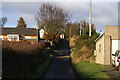
1
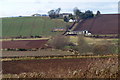
Hodgeton Farm and Cottages
Picture taken from the Gilchorn / Lunan Bank Road looking north.
Image: © Alan Morrison
Taken: 5 Mar 2009
0.03 miles
2
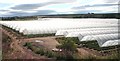
Polytunnels
They're no doubt great for growing soft fruit, but large acreages of polytunnels can be intrusive in the landscape.
Image: © Anne Burgess
Taken: 3 Aug 2006
0.12 miles
3
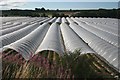
Polytunnels
These have almost a sinister look about them - they remind me of the sandworms in Frank Herbert's "Dune".
Image: © Anne Burgess
Taken: 3 Aug 2006
0.12 miles
4
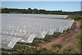
Polytunnels
These shelter a crop of strawberries. There were still a few left, though most of the crop had been harvested long since.
Image: © Anne Burgess
Taken: 3 Aug 2006
0.12 miles
6
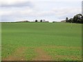
Hodgeton
A large field of oilseed rape.
Image: © Richard Webb
Taken: 27 Sep 2014
0.19 miles
7
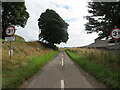
Weight restricted minor road at Bandoch
Looking north-eastward.
Image: © Peter Wood
Taken: 10 Aug 2021
0.24 miles