IMAGES TAKEN NEAR TO
ARBROATH, DD11 4RY
Introduction
This page details the photographs taken nearby to DD11 4RY by members of the Geograph project.
The Geograph project started in 2005 with the aim of publishing, organising and preserving representative images for every square kilometre of Great Britain, Ireland and the Isle of Man.

There are currently over 7.5m images from over14,400 individuals and you can help contribute to the project by visiting https://www.geograph.org.uk
Image Map
Images are licensed for reuse under creativecommons.org/licenses/by-sa/2.0
Notes
- Clicking on the map will re-center to the selected point.
- The higher the marker number, the further away the image location is from the centre of the postcode.
Image Listing (8 Images Found)
Images are licensed for reuse under creativecommons.org/licenses/by-sa/2.0
Image
Details
Distance
1
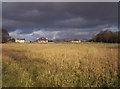
Poole Cottages and Storm Clouds
Image: © Dominic Dawn Harry and Jacob Paterson
Taken: 15 Feb 2006
0.02 miles
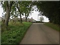
2
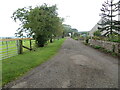
Track giving access to Poole
Looking north-westward.
Image: © Peter Wood
Taken: 10 Aug 2021
0.02 miles
3
Road to Poole Farm
Picture taken from the Fithie / Kinnell Road
Image: © Alan Morrison
Taken: 6 Feb 2009
0.04 miles
5
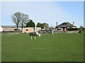
Horses at Poole
Two horses, big and small, in a field at Poole Farm.
Image: © Scott Cormie
Taken: 3 Apr 2022
0.05 miles
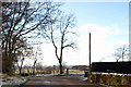
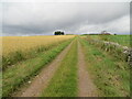
6
Poole
The top of a long gentle climb from Kinnell.
Image: © Richard Webb
Taken: 27 Sep 2014
0.06 miles
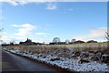
7
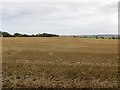
Stubble, Easter Braikie
Hilltop arable.
Image: © Richard Webb
Taken: 27 Sep 2014
0.12 miles
8
Field edge track ascending to Wuddy Law
Looking north-westward.
Image: © Peter Wood
Taken: 10 Aug 2021
0.18 miles