IMAGES TAKEN NEAR TO
Chapelton, ARBROATH, DD11 4RT
Introduction
This page details the photographs taken nearby to DD11 4RT by members of the Geograph project.
The Geograph project started in 2005 with the aim of publishing, organising and preserving representative images for every square kilometre of Great Britain, Ireland and the Isle of Man.

There are currently over 7.5m images from over14,400 individuals and you can help contribute to the project by visiting https://www.geograph.org.uk
Image Map
Images are licensed for reuse under creativecommons.org/licenses/by-sa/2.0
Notes
- Clicking on the map will re-center to the selected point.
- The higher the marker number, the further away the image location is from the centre of the postcode.
Image Listing (8 Images Found)
Images are licensed for reuse under creativecommons.org/licenses/by-sa/2.0
Image
Details
Distance
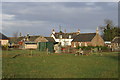
2

Cottages at Chapelton
On the right is a row of traditional cottages built of the local Old Red Sandstone. The one to the left is modern.
Image: © Anne Burgess
Taken: 3 Jun 2017
0.14 miles
3
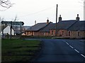
Crossroads at Chapelton near Arbroath
The crossroads is the junction of the Arbroath / Friockheim and Leysmill / Inverkeilor roads.
Image: © Alan Morrison
Taken: 27 Jan 2008
0.16 miles
4

Crossroads at Chapelton near Arbroath
Image: © Elliott Simpson
Taken: 5 Aug 2015
0.16 miles
5
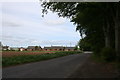
Crossroad Cottages
Cottages by the Chapelton crossroads.
Image: © Andrew Wood
Taken: 19 May 2011
0.17 miles
6

Shady Woods
This is just a small triangle of beech wood beside the crossroads, but it provides cool green shade on a hot day.
Image: © Anne Burgess
Taken: 3 Jun 2017
0.22 miles
7
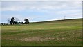
Stubble
A sloping arable field. The fence on the left keeps wind off a huge strawberry field.
Image: © Richard Webb
Taken: 27 Sep 2014
0.24 miles
8
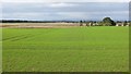
Westfield
One of the many big arable fields in the area, with a well established winter cereal crop.
Image: © Richard Webb
Taken: 27 Sep 2014
0.24 miles