IMAGES TAKEN NEAR TO
ARBROATH, DD11 4RR
Introduction
This page details the photographs taken nearby to DD11 4RR by members of the Geograph project.
The Geograph project started in 2005 with the aim of publishing, organising and preserving representative images for every square kilometre of Great Britain, Ireland and the Isle of Man.

There are currently over 7.5m images from over14,400 individuals and you can help contribute to the project by visiting https://www.geograph.org.uk
Image Map
Images are licensed for reuse under creativecommons.org/licenses/by-sa/2.0
Notes
- Clicking on the map will re-center to the selected point.
- The higher the marker number, the further away the image location is from the centre of the postcode.
Image Listing (17 Images Found)
Images are licensed for reuse under creativecommons.org/licenses/by-sa/2.0
Image
Details
Distance
1
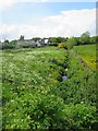
Burn at Leysmill
I'm not sure if this burn that runs through Leysmill has a name. It eventually joins the Colliston Burn to form the Brothock Burn.
Image: © Anne Burgess
Taken: 3 Jun 2017
0.03 miles
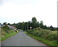
3
West Street, Leysmill
An ancestor lived in one of these houses between 1851 and 1871.
Image: © Graham Hogg
Taken: 15 May 2014
0.04 miles
4
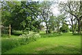
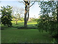
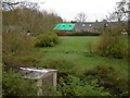
Village Green
The green was donated to the villagers by the landowner, Ramsay of Kinblethmont, on condition that they took over full responsibility for maintaining it. I am told that it is the only village green in Scotland that is actually owned by the community.
Image: © Anne Burgess
Taken: 3 Jun 2017
0.04 miles
5
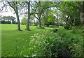
Village Green at Leysmill
Grassland and woodland at The Green in the centre of the small village of Leysmill.
Image: © Scott Cormie
Taken: 29 May 2020
0.05 miles
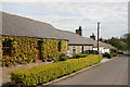
6
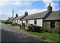
Cottages in Leysmill
This row of traditional cottages is on the western fringe of Leysmill.
Image: © Anne Burgess
Taken: 3 Jun 2017
0.05 miles
7
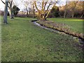
Village Green
The unnamed burn, looking very clean and clear, runs through the village green of Leysmill. The white house at top left is called Knockview, and was for a time an eventide home.
Image: © Anne Burgess
Taken: 3 Jun 2017
0.05 miles
8
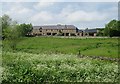
Leysmill
The farm steading at Leysmill has been converted to housing.
Image: © Anne Burgess
Taken: 3 Jun 2017
0.06 miles
9
Green, Leysmill
Looking across the burn to a reroofing project.
Image: © Richard Webb
Taken: 11 Nov 2015
0.06 miles
10
Brothock Burn at Leysmill, Angus
Taken from the Village Green at Leysmill
Image: © Alan Morrison
Taken: 27 Jan 2008
0.07 miles