IMAGES TAKEN NEAR TO
East Kirkton Road, ARBROATH, DD11 4HR
Introduction
This page details the photographs taken nearby to East Kirkton Road, DD11 4HR by members of the Geograph project.
The Geograph project started in 2005 with the aim of publishing, organising and preserving representative images for every square kilometre of Great Britain, Ireland and the Isle of Man.

There are currently over 7.5m images from over14,400 individuals and you can help contribute to the project by visiting https://www.geograph.org.uk
Image Map
Images are licensed for reuse under creativecommons.org/licenses/by-sa/2.0
Notes
- Clicking on the map will re-center to the selected point.
- The higher the marker number, the further away the image location is from the centre of the postcode.
Image Listing (7 Images Found)
Images are licensed for reuse under creativecommons.org/licenses/by-sa/2.0
Image
Details
Distance
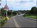
1
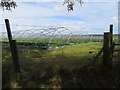
Strawberry field
Defended from neighbouring Kirkton by barbed wire.
Image: © Richard Webb
Taken: 27 Sep 2014
0.17 miles
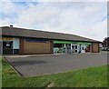
4
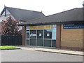
Millfield Kitchens
Chinese takeaway, Kirkton.
Image: © Richard Webb
Taken: 27 Sep 2014
0.18 miles
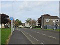
5
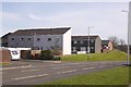
Kirkton, Arbroath
Kirkton Road, from outside the shops.
Image: © Richard Webb
Taken: 25 Mar 2016
0.22 miles
6
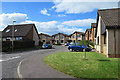
Cul-de-sac in East Kirkton
East Kirkton is an extensive development of mostly detached houses.
Image: © Anne Burgess
Taken: 7 Jun 2017
0.23 miles