IMAGES TAKEN NEAR TO
Tarry Road, ARBROATH, DD11 4BB
Introduction
This page details the photographs taken nearby to Tarry Road, DD11 4BB by members of the Geograph project.
The Geograph project started in 2005 with the aim of publishing, organising and preserving representative images for every square kilometre of Great Britain, Ireland and the Isle of Man.

There are currently over 7.5m images from over14,400 individuals and you can help contribute to the project by visiting https://www.geograph.org.uk
Image Map
Images are licensed for reuse under creativecommons.org/licenses/by-sa/2.0
Notes
- Clicking on the map will re-center to the selected point.
- The higher the marker number, the further away the image location is from the centre of the postcode.
Image Listing (7 Images Found)
Images are licensed for reuse under creativecommons.org/licenses/by-sa/2.0
Image
Details
Distance
1
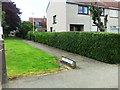
Brechin Road, Arbroath at its junction with St. Vigeans Road
Image: © Alan Morrison
Taken: 6 Feb 2009
0.05 miles
2
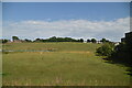
Gates of Driveway to North Tarry
The road to St. Vigeans can be clearly seen. Picture taken from Brechin Road, Arbroath.
Image: © Alan Morrison
Taken: 6 Feb 2009
0.08 miles
4
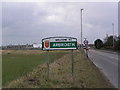
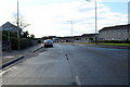
Welcome to Arbroath
Entrance to Arbroath from A92 from Montrose
Image: © Karen Vernon
Taken: 25 Feb 2005
0.15 miles
5
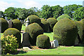
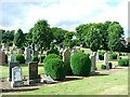
Yew Balls
There seem to be a huge number of neatly shaped yew bushes in this part of the Eastern Cemetery. It seems that yew, being evergreen, is regarded as symbolic of eternal life, hence the prevalence of it in burial grounds.
Image: © Anne Burgess
Taken: 7 Jun 2017
0.20 miles