IMAGES TAKEN NEAR TO
Warddykes Path, ARBROATH, DD11 4AT

Introduction

This page details the photographs taken nearby to Warddykes Path, DD11 4AT by members of the Geograph project.

The Geograph project started in 2005 with the aim of publishing, organising and preserving representative images for every square kilometre of Great Britain, Ireland and the Isle of Man.

There are currently over 7.5m images from over14,400 individuals and you can help contribute to the project by visiting https://www.geograph.org.uk

Image Map


Images are licensed for reuse under creativecommons.org/licenses/by-sa/2.0
Notes
  • Clicking on the map will re-center to the selected point.
  • The higher the marker number, the further away the image location is from the centre of the postcode.

Image Listing (20 Images Found)

Images are licensed for reuse under creativecommons.org/licenses/by-sa/2.0
Image
Details
Distance
1
Brechin Road, Arbroath at its junction with St. Vigeans Road
Image: © Alan Morrison Taken: 6 Feb 2009
0.15 miles
2
Trackside pasture
Image: © N Chadwick Taken: 29 Jul 2022
0.15 miles
3
Gates of Driveway to North Tarry
The road to St. Vigeans can be clearly seen. Picture taken from Brechin Road, Arbroath.
Image: © Alan Morrison Taken: 6 Feb 2009
0.16 miles
4
Yew Balls
There seem to be a huge number of neatly shaped yew bushes in this part of the Eastern Cemetery. It seems that yew, being evergreen, is regarded as symbolic of eternal life, hence the prevalence of it in burial grounds.
Image: © Anne Burgess Taken: 7 Jun 2017
0.17 miles
5
Tarry Dykes, Arbroath
Image: © Alex McGregor Taken: 3 Sep 2013
0.18 miles
6
Parish Hall
I think this is, or from the look of it was, the parish kirk hall of St Vigeans. It does not enhance the view from the mound on which the kirk stands.
Image: © Anne Burgess Taken: 13 Aug 2010
0.23 miles
7
Path at St. Vigeans, Angus
This path is part of Arbroath Path Network. It leads to Arbroath Town Centre. The Brothock Burn can just be seen to the right of the picture.
Image: © Alan Morrison Taken: 27 Jan 2008
0.23 miles
8
St. Vigeans Church
Mostly 15th century though parts date back to the 12th century. It underwent many "improvements" in the 19th century.
Image: © Bob Embleton Taken: 30 Oct 2008
0.23 miles
9
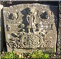
Gravestone in St. Vigeans Churchyard
One of several old gravestones lining the eastern edge of the graveyard. This one inscribed with the names of John Spinks and Agnes Spinks is adorned with some crudely attractive carvings.
Image: © Bob Embleton Taken: 30 Oct 2008
0.24 miles
10
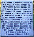
St. Vigeans War Memorial - West Face
Gordon Highlanders, Cameron highlanders, Argyll and Sutherland Highlanders, Seaforth Highlanders, Highland Light Infantry. Image
Image: © Bob Embleton Taken: 30 Oct 2008
0.24 miles