IMAGES TAKEN NEAR TO
ARBROATH, DD11 3SF
Introduction
This page details the photographs taken nearby to DD11 3SF by members of the Geograph project.
The Geograph project started in 2005 with the aim of publishing, organising and preserving representative images for every square kilometre of Great Britain, Ireland and the Isle of Man.

There are currently over 7.5m images from over14,400 individuals and you can help contribute to the project by visiting https://www.geograph.org.uk
Image Map
Images are licensed for reuse under creativecommons.org/licenses/by-sa/2.0
Notes
- Clicking on the map will re-center to the selected point.
- The higher the marker number, the further away the image location is from the centre of the postcode.
Image Listing (4 Images Found)
Images are licensed for reuse under creativecommons.org/licenses/by-sa/2.0
Image
Details
Distance
1
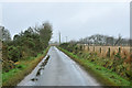
Minor road near West Mill of Colliston
Image: © Steven Brown
Taken: 20 Nov 2012
0.08 miles
3
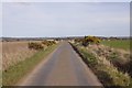
Yellow road near Colliston
The road accesses several farms.
Image: © Richard Webb
Taken: 25 Mar 2016
0.15 miles
4
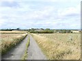
West Mill of Colliston
Mill on the Colliston Burn.
Image: © James Allan
Taken: 28 Aug 2006
0.22 miles