IMAGES TAKEN NEAR TO
ARBROATH, DD11 3RW
Introduction
This page details the photographs taken nearby to DD11 3RW by members of the Geograph project.
The Geograph project started in 2005 with the aim of publishing, organising and preserving representative images for every square kilometre of Great Britain, Ireland and the Isle of Man.

There are currently over 7.5m images from over14,400 individuals and you can help contribute to the project by visiting https://www.geograph.org.uk
Image Map
Images are licensed for reuse under creativecommons.org/licenses/by-sa/2.0
Notes
- Clicking on the map will re-center to the selected point.
- The higher the marker number, the further away the image location is from the centre of the postcode.
Image Listing (5 Images Found)
Images are licensed for reuse under creativecommons.org/licenses/by-sa/2.0
Image
Details
Distance
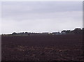
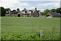
1
Mid Peebles
Set amongst Angus arable land.
Image: © Richard Webb
Taken: 11 Nov 2015
0.01 miles
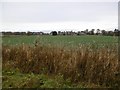
2
Mid Peebles
A solid-looking traditional steading at Mid Peebles Farm.
Image: © Anne Burgess
Taken: 7 Jun 2017
0.02 miles
3
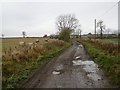
This is a yellow road
A very poor road near Mid Peebles, Angus. Much of the black top has gone.
Image: © Richard Webb
Taken: 11 Nov 2015
0.10 miles
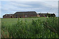
4
Denside Farm
Farm house and buildings viewed from the old public road.
Image: © Anne Burgess
Taken: 7 Jun 2017
0.19 miles