IMAGES TAKEN NEAR TO
Colliston, ARBROATH, DD11 3RU
Introduction
This page details the photographs taken nearby to DD11 3RU by members of the Geograph project.
The Geograph project started in 2005 with the aim of publishing, organising and preserving representative images for every square kilometre of Great Britain, Ireland and the Isle of Man.

There are currently over 7.5m images from over14,400 individuals and you can help contribute to the project by visiting https://www.geograph.org.uk
Image Map
Images are licensed for reuse under creativecommons.org/licenses/by-sa/2.0
Notes
- Clicking on the map will re-center to the selected point.
- The higher the marker number, the further away the image location is from the centre of the postcode.
Image Listing (4 Images Found)
Images are licensed for reuse under creativecommons.org/licenses/by-sa/2.0
Image
Details
Distance
1
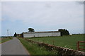
West Muirhouse
West Muirhouse farm by Leysmill.
Image: © Andrew Wood
Taken: 19 May 2011
0.06 miles
2
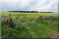
Field Gate near West Muirhouse
I think the crops is barley. Muirpark Wood is in the distance, but still in this square.
Image: © Anne Burgess
Taken: 3 Jun 2017
0.09 miles
4
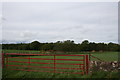
Red Gate by Muirpark
Through the red gate ,and the field beyond , lies Muirpark Wood.
Image: © Andrew Wood
Taken: 19 May 2011
0.19 miles