IMAGES TAKEN NEAR TO
ARBROATH, DD11 3RB
Introduction
This page details the photographs taken nearby to DD11 3RB by members of the Geograph project.
The Geograph project started in 2005 with the aim of publishing, organising and preserving representative images for every square kilometre of Great Britain, Ireland and the Isle of Man.

There are currently over 7.5m images from over14,400 individuals and you can help contribute to the project by visiting https://www.geograph.org.uk
Image Map
Images are licensed for reuse under creativecommons.org/licenses/by-sa/2.0
Notes
- Clicking on the map will re-center to the selected point.
- The higher the marker number, the further away the image location is from the centre of the postcode.
Image Listing (4 Images Found)
Images are licensed for reuse under creativecommons.org/licenses/by-sa/2.0
Image
Details
Distance
1
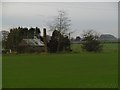
Rosely
A building with a substantial chimney, did it once house an engine?
Image: © Richard Webb
Taken: 11 Nov 2015
0.12 miles
2
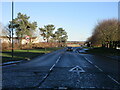
Kirkton Road, Arbroath
Looking along Kirkton Road from its termination with the A933.
Image: © Scott Cormie
Taken: 2 Jan 2021
0.18 miles
3
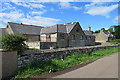
Mains of Millfield or Woodley
The modern maps don't name these buildings, but the first edition of the six-inch Ordnance Survey map says it is Mains of Millfield. Later editions name one of the buildings Woodley. I think the nearer building post-dates all the Victorian maps.
Image: © Anne Burgess
Taken: 7 Jun 2017
0.18 miles
4
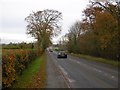
Forfar Road leaves Arbroath
The A933 towards Friockheim.
Image: © Richard Webb
Taken: 11 Nov 2015
0.19 miles