IMAGES TAKEN NEAR TO
East Muirlands Road, ARBROATH, DD11 3HF
Introduction
This page details the photographs taken nearby to East Muirlands Road, DD11 3HF by members of the Geograph project.
The Geograph project started in 2005 with the aim of publishing, organising and preserving representative images for every square kilometre of Great Britain, Ireland and the Isle of Man.

There are currently over 7.5m images from over14,400 individuals and you can help contribute to the project by visiting https://www.geograph.org.uk
Image Map
Images are licensed for reuse under creativecommons.org/licenses/by-sa/2.0
Notes
- Clicking on the map will re-center to the selected point.
- The higher the marker number, the further away the image location is from the centre of the postcode.
Image Listing (3 Images Found)
Images are licensed for reuse under creativecommons.org/licenses/by-sa/2.0
Image
Details
Distance
2
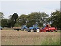
Potato harvest
Workforce and machinery assemble to harvest an enormous field Image at Crudie on the edge of Arbroath. The trees are on the boundary of a cemetery.
Image: © Richard Webb
Taken: 27 Sep 2014
0.23 miles
3
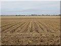
Potato field
A few weeks after Image the crop has been defoliated and is about to be lifted. The machinery had just arrived.Image
Image: © Richard Webb
Taken: 27 Sep 2014
0.24 miles