IMAGES TAKEN NEAR TO
Keptie Road, ARBROATH, DD11 3EB
Introduction
This page details the photographs taken nearby to Keptie Road, DD11 3EB by members of the Geograph project.
The Geograph project started in 2005 with the aim of publishing, organising and preserving representative images for every square kilometre of Great Britain, Ireland and the Isle of Man.

There are currently over 7.5m images from over14,400 individuals and you can help contribute to the project by visiting https://www.geograph.org.uk
Image Map
Images are licensed for reuse under creativecommons.org/licenses/by-sa/2.0
Notes
- Clicking on the map will re-center to the selected point.
- The higher the marker number, the further away the image location is from the centre of the postcode.
Image Listing (33 Images Found)
Images are licensed for reuse under creativecommons.org/licenses/by-sa/2.0
Image
Details
Distance
1

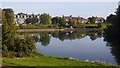
Houses overlooking Keptie Pond
Houses at the northern end of Keptie Pond
Image: © Sandy Gerrard
Taken: 25 Jul 2009
0.04 miles
2
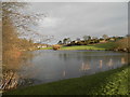
Keptie Pond, Arbroath
Marked on old maps as a skating pond, it is the centrepiece of a park.
Image: © Richard Webb
Taken: 23 Sep 2017
0.08 miles
3
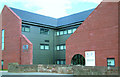
Angus College, CALC Building
Angus College, new CALC building, front.
Image: © Pacifika
Taken: 15 Dec 2004
0.09 miles
4
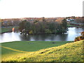
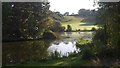
Keptie Pond
Taken from the top of Keptie Hill beside the Water Tower.
Image: © Derek Robertson
Taken: 25 Nov 2001
0.09 miles
5
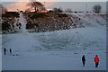
Keptie Pond
The pond will often freeze over in winter, but this year has been the first winter in a while that the ice couls be safely walked on. Figures in the foreground were walking over the ice. Just outside the picture were a group of lads on their bikes.
Image: © Karen Vernon
Taken: 31 Dec 2009
0.11 miles
7
Keptie Pond, Arbroath
Marked on old maps as a skating pond, it is the centrepiece of a park.
Image: © Richard Webb
Taken: 23 Sep 2017
0.11 miles
8
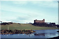
Keptie Pond and the water tower, Arbroath
Image: © Elliott Simpson
Taken: 17 Feb 1968
0.12 miles
9
First World War Dog Grave
At the bottom of Arbroath High School's back steps is the grave of a dog, "Paddy" was the regimental mascot of the troops stationed there when there was an army barracks on the site.
Image: © Derek Robertson
Taken: 29 Nov 2005
0.13 miles
10
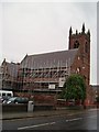
Arbroath West Kirk
Originally opened in 1879 as St Margaret's Chapel of Ease, the building is currently undergoing extensive stonework restoration.
Image: © Douglas Nelson
Taken: 10 Jul 2016
0.14 miles