IMAGES TAKEN NEAR TO
Arbirlot, ARBROATH, DD11 2PZ
Introduction
This page details the photographs taken nearby to DD11 2PZ by members of the Geograph project.
The Geograph project started in 2005 with the aim of publishing, organising and preserving representative images for every square kilometre of Great Britain, Ireland and the Isle of Man.

There are currently over 7.5m images from over14,400 individuals and you can help contribute to the project by visiting https://www.geograph.org.uk
Image Map
Images are licensed for reuse under creativecommons.org/licenses/by-sa/2.0
Notes
- Clicking on the map will re-center to the selected point.
- The higher the marker number, the further away the image location is from the centre of the postcode.
Image Listing (6 Images Found)
Images are licensed for reuse under creativecommons.org/licenses/by-sa/2.0
Image
Details
Distance
1
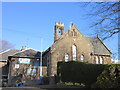
Arbirlot Primary School
Arbirlot Primary School viewed from the roadside to the south.
Image: © Scott Cormie
Taken: 31 Mar 2019
0.07 miles
2
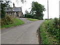
Minor road at Airbirlot Primary School
Looking eastward.
Image: © Peter Wood
Taken: 11 Aug 2021
0.07 miles
3
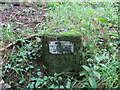
Ordnance Survey Fundamental Bench Mark
This can be found in woodland near to Easter Knox.
The recorded details give a height of 89.8 metres above sea level.
For more detail see :https://www.bench-marks.org.uk/bm997
Image: © Peter Wood
Taken: 11 Aug 2021
0.12 miles
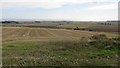
4
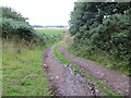
Track near to Easter Knox and Knox Hill
Looking north-westward.
Image: © Peter Wood
Taken: 11 Aug 2021
0.15 miles
6
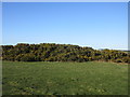
Gorse on Knox Hill
Gorse covered hillock on the summit area of Knox Hill. The triangulation pillar is situated within the bushes towards the centre of the photograph.
Image: © Scott Cormie
Taken: 31 Mar 2019
0.23 miles