IMAGES TAKEN NEAR TO
ARBROATH, DD11 2PY
Introduction
This page details the photographs taken nearby to DD11 2PY by members of the Geograph project.
The Geograph project started in 2005 with the aim of publishing, organising and preserving representative images for every square kilometre of Great Britain, Ireland and the Isle of Man.

There are currently over 7.5m images from over14,400 individuals and you can help contribute to the project by visiting https://www.geograph.org.uk
Image Map
Images are licensed for reuse under creativecommons.org/licenses/by-sa/2.0
Notes
- Clicking on the map will re-center to the selected point.
- The higher the marker number, the further away the image location is from the centre of the postcode.
Image Listing (3 Images Found)
Images are licensed for reuse under creativecommons.org/licenses/by-sa/2.0
Image
Details
Distance
2
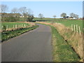
Road heading to Bonnyton Smiddy
The minor road heading west, with Bonnyton Smiddy in the distance to the right.
Image: © Scott Cormie
Taken: 31 Mar 2019
0.17 miles
3
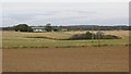
Greenford
Hilltop arable land on the eastern tail of the Sidlaw Hills.
Image: © Richard Webb
Taken: 27 Sep 2014
0.23 miles