IMAGES TAKEN NEAR TO
ARBROATH, DD11 2PD
Introduction
This page details the photographs taken nearby to DD11 2PD by members of the Geograph project.
The Geograph project started in 2005 with the aim of publishing, organising and preserving representative images for every square kilometre of Great Britain, Ireland and the Isle of Man.

There are currently over 7.5m images from over14,400 individuals and you can help contribute to the project by visiting https://www.geograph.org.uk
Image Map
Images are licensed for reuse under creativecommons.org/licenses/by-sa/2.0
Notes
- Clicking on the map will re-center to the selected point.
- The higher the marker number, the further away the image location is from the centre of the postcode.
Image Listing (11 Images Found)
Images are licensed for reuse under creativecommons.org/licenses/by-sa/2.0
Image
Details
Distance
1
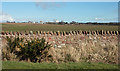
Field Wall near Elliott
A fine example of a rubble wall runs along the edge of a field west of Elliott. The buildings are in the next square.
Image: © Anne Burgess
Taken: 27 Mar 2013
0.11 miles
3
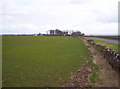
Balcathie and Grassy Field
Image: © Dominic Dawn Harry and Jacob Paterson
Taken: 24 Feb 2006
0.11 miles
4
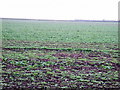
Ploughed Land at Balcathie
Recently ploughed, may even have been seeded, and remarkably dry in spite of recent wet weather. Balcathie Farm house is at the far side of the field.
Image: © Anne Burgess
Taken: 27 Mar 2013
0.13 miles
5
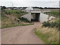
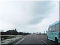
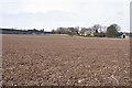
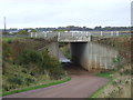
Underpass, Balcathie
Underpass linking farmland on either side of the A92.
Image: © Richard Webb
Taken: 7 Sep 2009
0.13 miles

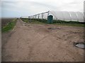
8
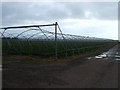
Polytunnels (without the poly)
Crops under cover.
Image: © JThomas
Taken: 23 Oct 2013
0.19 miles
9
Polytunnels, Elliot
Tunnels that sheltered soft fruit. On the left there is a potato field which has been treated with sulphuric acid to kill off the leaves.
Image: © Richard Webb
Taken: 7 Sep 2009
0.19 miles