IMAGES TAKEN NEAR TO
Arbirlot, ARBROATH, DD11 2PA
Introduction
This page details the photographs taken nearby to DD11 2PA by members of the Geograph project.
The Geograph project started in 2005 with the aim of publishing, organising and preserving representative images for every square kilometre of Great Britain, Ireland and the Isle of Man.

There are currently over 7.5m images from over14,400 individuals and you can help contribute to the project by visiting https://www.geograph.org.uk
Image Map
Images are licensed for reuse under creativecommons.org/licenses/by-sa/2.0
Notes
- Clicking on the map will re-center to the selected point.
- The higher the marker number, the further away the image location is from the centre of the postcode.
Image Listing (3 Images Found)
Images are licensed for reuse under creativecommons.org/licenses/by-sa/2.0
Image
Details
Distance
1
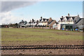
House near Kellie Castle
This row of houses isn't named on the maps. They line the road of which the private drive to Kellie Castle is an extension.
Image: © Anne Burgess
Taken: 27 Mar 2013
0.01 miles
2
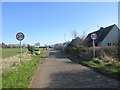
Mains of Kelly road
The road from the Mains of Kelly heading past the houses south of Arbirlot.
Image: © Scott Cormie
Taken: 31 Mar 2019
0.02 miles
3
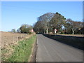
Road to Arbirlot
The road heading to Arbirlot from the south.
Image: © Scott Cormie
Taken: 31 Mar 2019
0.23 miles