IMAGES TAKEN NEAR TO
West Port, ARBROATH, DD11 1RE
Introduction
This page details the photographs taken nearby to West Port, DD11 1RE by members of the Geograph project.
The Geograph project started in 2005 with the aim of publishing, organising and preserving representative images for every square kilometre of Great Britain, Ireland and the Isle of Man.

There are currently over 7.5m images from over14,400 individuals and you can help contribute to the project by visiting https://www.geograph.org.uk
Image Map
Images are licensed for reuse under creativecommons.org/licenses/by-sa/2.0
Notes
- Clicking on the map will re-center to the selected point.
- The higher the marker number, the further away the image location is from the centre of the postcode.
Image Listing (194 Images Found)
Images are licensed for reuse under creativecommons.org/licenses/by-sa/2.0
Image
Details
Distance
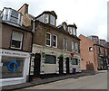
5
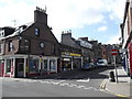
West Port, Arbroath near its junction with Millgate Loan
Image: © Alan Morrison
Taken: 4 Sep 2012
0.03 miles
6
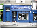
Unusual numbering
No. 15½ West Port, next to a computer shop.
Image: © Richard Webb
Taken: 7 Sep 2009
0.03 miles
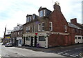
7
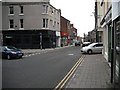
West Port, Arbroath
Near the junction with Catherine Street.
Image: © Richard Webb
Taken: 7 Sep 2009
0.03 miles
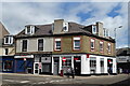
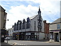
9
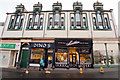
14-18 Keptie Street
This notable building was built as a chapel in 1879 with shops on the ground floor. It is now subdivided into flats. For more information on its history see http://www.scottishchurches.org.uk/sites/site/id/9791/name/Evangelical+Union+Congregation%2C+Arbroath+Arbroath+and+St+Vigeans+Tayside.
(The image is distorted because a wide-angle lens was used to take the picture from across a narrow street.)
Image: © Rob Burke
Taken: 21 Jan 2012
0.03 miles
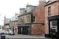
10
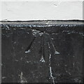
Benchmark, Stag Inn
Detail of an Ordnance Survey pivot benchmark on the painted plinth of the Stag Inn at the junction of West Port and Millgate. The benchmark marks a height of 7.2177m above mean sea level (Ordnance Datum Newlyn) last verified in 1971 (location photograph Image).
Image: © Adrian Taylor
Taken: 29 Aug 2020
0.04 miles