IMAGES TAKEN NEAR TO
Stoneycroft Lane, ARBROATH, DD11 1PY
Introduction
This page details the photographs taken nearby to Stoneycroft Lane, DD11 1PY by members of the Geograph project.
The Geograph project started in 2005 with the aim of publishing, organising and preserving representative images for every square kilometre of Great Britain, Ireland and the Isle of Man.

There are currently over 7.5m images from over14,400 individuals and you can help contribute to the project by visiting https://www.geograph.org.uk
Image Map
Images are licensed for reuse under creativecommons.org/licenses/by-sa/2.0
Notes
- Clicking on the map will re-center to the selected point.
- The higher the marker number, the further away the image location is from the centre of the postcode.
Image Listing (212 Images Found)
Images are licensed for reuse under creativecommons.org/licenses/by-sa/2.0
Image
Details
Distance
1
The Bell Rock Takeaway Restaurant
On Ladyloan; battered Arbroath Smokies and Chips a speciality.
Image: © Stanley Howe
Taken: 4 Jul 2015
0.05 miles
2
Lady Loan approaching Dundee Road, Arbroath
Image: © Mark Anderson
Taken: 21 Aug 2021
0.06 miles
3

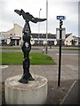
Millennium Milepost, National Cycle Route 1, Arbroath
Image: © JThomas
Taken: 14 Jun 2021
0.06 miles
4
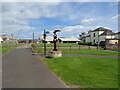
National Cycle Network route 1 signpost
Image: © Richard Webb
Taken: 7 Sep 2009
0.07 miles
5
National Cycle Route 1 passing Signal Tower Museum, Arbroath
Image: © JThomas
Taken: 14 Jun 2021
0.07 miles
7
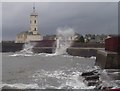
Signal Tower Museum
The Signal Tower Museum here in stormy weather was once the shore dwelling of the Bell Rock Lighthouse keepers. In the foreground to the bottom right is the remains of the old boatbuilders yard Gerrards.
Image: © Derek Robertson
Taken: 25 Oct 2005
0.08 miles
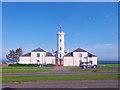
9
Signal Tower Museum, Arbroath
Built in 1813 as a base of operations for the Bell Rock Lighthouse. Signalling apparatus installed at the top of the tower building was used to communicate between the shore staff and the lighthouse keepers.
Image: © JThomas
Taken: 14 Jun 2021
0.08 miles
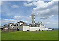
10
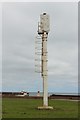
Navigation markers, Arbroath Harbour
The leading lights on the tower in the foreground and the white column in the distance line up to mark the centre of the channel between the breakwaters, aiding the safe navigation of boats into the harbour.
Image: © Graham Robson
Taken: 29 Apr 2019
0.09 miles