IMAGES TAKEN NEAR TO
Rossie Woods, MONTROSE, DD10 9TS
Introduction
This page details the photographs taken nearby to Rossie Woods, DD10 9TS by members of the Geograph project.
The Geograph project started in 2005 with the aim of publishing, organising and preserving representative images for every square kilometre of Great Britain, Ireland and the Isle of Man.

There are currently over 7.5m images from over14,400 individuals and you can help contribute to the project by visiting https://www.geograph.org.uk
Image Map
Images are licensed for reuse under creativecommons.org/licenses/by-sa/2.0
Notes
- Clicking on the map will re-center to the selected point.
- The higher the marker number, the further away the image location is from the centre of the postcode.
Image Listing (6 Images Found)
Images are licensed for reuse under creativecommons.org/licenses/by-sa/2.0
Image
Details
Distance
1
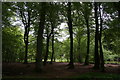
Rossie Woodland
Mature woodland at Rossie.
Image: © Andrew Wood
Taken: 18 May 2011
0.14 miles
2
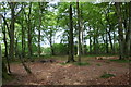
Rossie Wood
Woodland near Rossie school.
Image: © Andrew Wood
Taken: 18 May 2011
0.16 miles
3
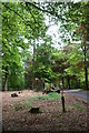
Rossie Stump
A tree stump in woodland at Rossie.
Image: © Andrew Wood
Taken: 18 May 2011
0.16 miles
4
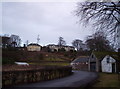
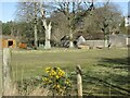
Rossie School House
A correction facility for minors near Montrose
Image: © Dominic Dawn Harry and Jacob Paterson
Taken: 26 Dec 2005
0.23 miles
5
Spot the donkeys
Two donkeys in a paddock near Rossie School.
Image: © Scott Cormie
Taken: 3 Apr 2022
0.23 miles
6
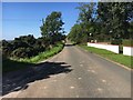
Lane to Rossie School
By Mountboy the lane to Rossie School
Image: © Shaun Ferguson
Taken: 31 Aug 2018
0.25 miles