IMAGES TAKEN NEAR TO
MONTROSE, DD10 9TJ
Introduction
This page details the photographs taken nearby to DD10 9TJ by members of the Geograph project.
The Geograph project started in 2005 with the aim of publishing, organising and preserving representative images for every square kilometre of Great Britain, Ireland and the Isle of Man.

There are currently over 7.5m images from over14,400 individuals and you can help contribute to the project by visiting https://www.geograph.org.uk
Image Map
Images are licensed for reuse under creativecommons.org/licenses/by-sa/2.0
Notes
- Clicking on the map will re-center to the selected point.
- The higher the marker number, the further away the image location is from the centre of the postcode.
Image Listing (9 Images Found)
Images are licensed for reuse under creativecommons.org/licenses/by-sa/2.0
Image
Details
Distance
1
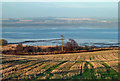
At Montrose Basin
A November view taken from the A934 looking towards the basin.
Image: © Mary and Angus Hogg
Taken: 16 Nov 2018
0.10 miles
3
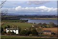
Maryton, Montrose
Looking north towards Maryton Farm, Montrose Basin and into the distant Grampian Mountains
Image: © Alan Morrison
Taken: 9 Mar 2008
0.16 miles
4
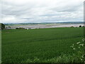
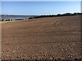
Cereal crop, Maryton
Looking towards the Montrose Basin.
Image: © JThomas
Taken: 13 Jun 2021
0.17 miles
6
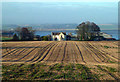
Field above Maryton
Field above Maryton looking in the distance to the Basin and Montrose
Image: © Shaun Ferguson
Taken: 31 Aug 2018
0.20 miles
7
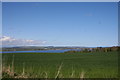
Denhead Grassland
Grassland on a relatively high spot above Montrose with a view of Montrose Basin in the distance.
Image: © Andrew Wood
Taken: 12 May 2010
0.23 miles
8
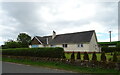
Maryton Farm
Located on the southern edge of Montrose Basin.
Image: © Mary and Angus Hogg
Taken: 16 Nov 2018
0.23 miles
9
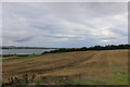
Wheat stubble on Rossie Braes
This photo shows wheat stubble on Rossie Braes.
Image: © Andrew Diack
Taken: 18 Aug 2018
0.24 miles