IMAGES TAKEN NEAR TO
Lighthouse Road, MONTROSE, DD10 9SJ
Introduction
This page details the photographs taken nearby to Lighthouse Road, DD10 9SJ by members of the Geograph project.
The Geograph project started in 2005 with the aim of publishing, organising and preserving representative images for every square kilometre of Great Britain, Ireland and the Isle of Man.

There are currently over 7.5m images from over14,400 individuals and you can help contribute to the project by visiting https://www.geograph.org.uk
Image Map
Images are licensed for reuse under creativecommons.org/licenses/by-sa/2.0
Notes
- Clicking on the map will re-center to the selected point.
- The higher the marker number, the further away the image location is from the centre of the postcode.
Image Listing (120 Images Found)
Images are licensed for reuse under creativecommons.org/licenses/by-sa/2.0
Image
Details
Distance
1
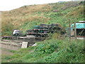
Creels near the eastern end of River Street, Ferryden
This photo shows a stack of creels or lobster pots which are located a short distance beyond the eastern end of River Street and at the foot of the embankment of the South Esk estuary. This site marks the extreme, eastern end of Ferryden.
Image: © Adrian Diack
Taken: 18 Aug 2020
0.02 miles
3
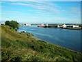
Banks of the River South Esk
This photo shows a view of the banks of the River South Esk near Ferryden.
Image: © Adrian Diack
Taken: 25 Jul 2016
0.03 miles
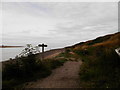
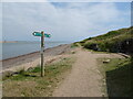
4
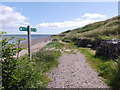
Angus Coastal Path
From the east end of William St, Ferryden. The riverside path is badly eroded, but the steps close right (beyond the lobster pots) lead up to Beacon Terrace, an alternative parallel surfaced track to Scurdie Ness Lighthouse.
Image: © Stanley Howe
Taken: 24 Jul 2015
0.03 miles
5
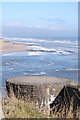
Wartime Pillbox
An old WW2 pillbox, I think there was Polish involvement in the building of this and another a bit further along, which were linked by tunnels (now collapsed)
Image: © Jacqueline Hamilton
Taken: 16 Mar 2011
0.03 miles
7
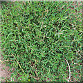
Equal-leaved Knotweed (Polygonum arenastrum)
It's not always easy to tell this from the similar Knotweed (P Aviculare) but it is plentiful around Scurdie Ness.
Image: © Anne Burgess
Taken: 5 Aug 2022
0.03 miles
8
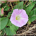
Hairy Bindweed (Calystegia pulchra)
In a large patch just east of Ferryden village.
Image: © Anne Burgess
Taken: 5 Aug 2022
0.03 miles